Harmanlı geodata
Harmanlı (Adıyaman) is a seat of a third-order administrative division; located in Turkey in Europe/Istanbul (GMT+3) time zone. In our database, there are 1323 cities with bigger population. Compared to other cities in Turkey, 67.4% of cities are located further ↑North; 60% of cities are located further ←West and 77.3% of cities have lower elevation than Harmanlı. Note1


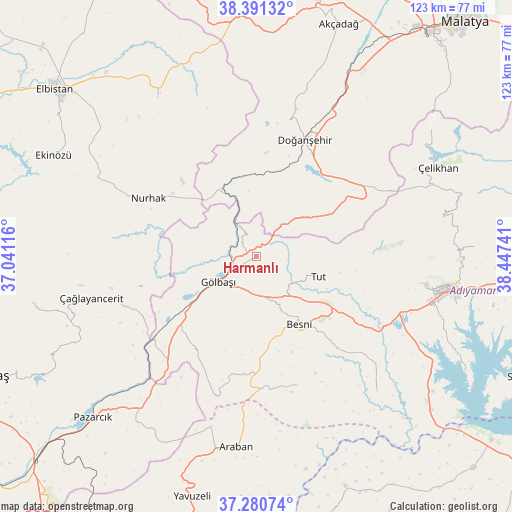
Harmanlı GPS coordinates[2]
37° 50' 17.232" North, 37° 44' 39.408" East
| Map corner | latitude | longitude |
|---|---|---|
| Upper-left | 38.39132°, | 37.04116° |
| Center: | 37.83812°, | 37.74428° |
| Lower-right: | 37.28074°, | 38.44741° |
| Map W x H: | 123.5×123.5 km | = 76.7×76.7mi |
| max Lat: | 42.02683° ⇑67.4% North |
| Harmanlı: | 37.83812° |
| min Lat: | ⇓32.6% South 35.9025° |
| min Long | Harmanlı | max Long |
| 25.90902° | 37.74428° | 44.60099° |
| W 60%⇐ | ⇒40% E |
Elevation
Elevation of Harmanlı is 1141 m = 3743 ft, and this is 423.6 m = 1390 ft above average elevation for this country.
| Max E: |
2682 m = 8799 ft | 22.7% |
| Harmanlı | 1141 m 3743 ft | |
| Avg. | 717.4 m = 2354 ft | |
Min E: |
0 m = 0 ft | 77.3% |
See also: Turkey elevation on elevation.city.
Geographical zone
Harmanlı is located in North temperate zone (between Tropic of Cancer and the Arctic Circle). Distance of this Northern Tropic circle is 1601.3 km =995 mi to South.| Distance of | km | miles | from Harmanlı |
|---|---|---|---|
| North Pole | 5799.9 | 3603.9 | to North |
| Arctic Circle | 3194 | 1984.7 | to North |
| Tropic Cancer | 1601.3 | 995 | to South |
| Equator | 4207.2 | 2614.2 | to South |


Nearby cities:
15 places around Harmanlı: (largest is in red/bold)
• Araban
46 km =28.6 mi,  186°
186°
• Belören
26.6 km =16.5 mi,  212°
212°
• Besni
19.1 km =11.9 mi,  147°
147°
• Doğanşehir
29.7 km =18.5 mi,  21°
21°
• Gölbaşı
11.2 km =7 mi,  237°
237°
• Gücük
45.8 km =28.5 mi,  329°
329°
• Keysun
32.4 km =20.1 mi,  162°
162°
• Koçali
46.1 km =28.6 mi,  78°
78°
• Kızılin
43.6 km =27.1 mi,  137°
137°
• Nurhak
30.1 km =18.7 mi,  297°
297°
• Suvarlı
34.7 km =21.6 mi,  196°
196°
• Sürgü
26.8 km =16.7 mi,  45°
45°
• Tut
15.8 km =9.8 mi,  107°
107°
• Çağlayancerit
41.6 km =25.8 mi,  255°
255°
• Şambayat
31.6 km =19.6 mi,  122°
122°
Sources, notices
• [Note1] Compared only with cities in Turkey existing in our database
• [Src1] Map data: © OpenStreetMap contributors (CC-BY-SA)
• [Src2] Other city data from geonames.org with taken over terms of usage.
• [Src3] Geographical zone / Annual Mean Temperature by Robert A. Rohde @ Wikipedia
