Adıyaman geodata
Adıyaman is a seat of a first-order administrative division; located in Turkey in Europe/Istanbul (GMT+3) time zone. With population of 223,744 people, there are 45 cities with bigger population in this country. Compared to other cities in Turkey, 69.2% of cities are located further ↑North; 63% of cities are located further ←West and 50.6% of cities have higher elevation than Adıyaman. Note1


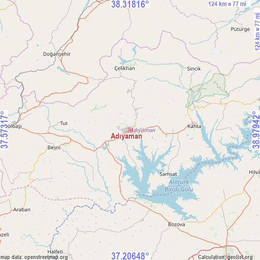
Adıyaman GPS coordinates[2]
37° 45' 51.876" North, 38° 16' 34.644" East
| Map corner | latitude | longitude |
|---|---|---|
| Upper-left | 38.31816°, | 37.57317° |
| Center: | 37.76441°, | 38.27629° |
| Lower-right: | 37.20648°, | 38.97942° |
| Map W x H: | 123.6×123.6 km | = 76.8×76.8mi |
| max Lat: | 42.02683° ⇑69.2% North |
| Adıyaman: | 37.76441° |
| min Lat: | ⇓30.8% South 35.9025° |
| min Long | Adıyaman | max Long |
| 25.90902° | 38.27629° | 44.60099° |
| W 63%⇐ | ⇒37% E |
Elevation
Elevation of Adıyaman is 678 m = 2224 ft, and this is 39.4 m = 129 ft below average elevation for this country.
| Max E: |
2682 m = 8799 ft | 50.6% |
| Avg. | 717.4 m = 2354 ft | |
| Adıyaman | 678 m = 2224 ft | |
Min E: |
0 m = 0 ft | 49.4% |
See also: Adıyaman elevation on elevation.city.
Geographical zone
Adıyaman is located in North temperate zone (between Tropic of Cancer and the Arctic Circle). Distance of this Northern Tropic circle is 1593.1 km =989.9 mi to South.| Distance of | km | miles | from Adıyaman |
|---|---|---|---|
| North Pole | 5808.1 | 3609 | to North |
| Arctic Circle | 3202.2 | 1989.8 | to North |
| Tropic Cancer | 1593.1 | 989.9 | to South |
| Equator | 4199 | 2609.1 | to South |


Nearby cities:
15 places around Adıyaman: (largest is in red/bold)
• Akpınar
21.7 km =13.5 mi,  192°
192°
• Bağpınar
19.6 km =12.2 mi,  168°
168°
• Besni
37.4 km =23.2 mi,  257°
257°
• Damlacık
37.1 km =23.1 mi,  63°
63°
• Koçali
17.7 km =11 mi,  354°
354°
• Kuyucak
12.5 km =7.8 mi,  28°
28°
• Kâhta
30.6 km =19 mi,  85°
85°
• Kızılin
29.9 km =18.6 mi,  216°
216°
• Samsat
26.7 km =16.6 mi,  139°
139°
• Sincik
42.3 km =26.3 mi,  44°
44°
• Sürgü
38.4 km =23.9 mi,  314°
314°
• Tut
31.8 km =19.8 mi,  276°
276°
• Yarpuzlu
38.7 km =24 mi, 33°
• Çelikhan
29.2 km =18.1 mi, 353°
• Şambayat
22.1 km =13.7 mi,  246°
246°
Sources, notices
• [Note1] Compared only with cities in Turkey existing in our database
• [Src1] Map data: © OpenStreetMap contributors (CC-BY-SA)
• [Src2] Other city data from geonames.org with taken over terms of usage.
• [Src3] Geographical zone / Annual Mean Temperature by Robert A. Rohde @ Wikipedia
