Akpınar geodata
Akpınar (Adıyaman) is a seat of a third-order administrative division; located in Turkey in Europe/Istanbul (GMT+3) time zone. In our database, there are 1323 cities with bigger population. Compared to other cities in Turkey, 72.8% of cities are located further ↑North; 62.6% of cities are located further ←West and 53.8% of cities have higher elevation than Akpınar. Note1


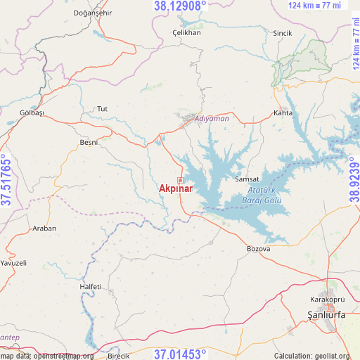
Akpınar GPS coordinates[2]
37° 34' 26.004" North, 38° 13' 14.772" East
| Map corner | latitude | longitude |
|---|---|---|
| Upper-left | 38.12908°, | 37.51765° |
| Center: | 37.57389°, | 38.22077° |
| Lower-right: | 37.01453°, | 38.9239° |
| Map W x H: | 123.9×123.9 km | = 77×77mi |
| max Lat: | 42.02683° ⇑72.8% North |
| Akpınar: | 37.57389° |
| min Lat: | ⇓27.2% South 35.9025° |
| min Long | Akpınar | max Long |
| 25.90902° | 38.22077° | 44.60099° |
| W 62.6%⇐ | ⇒37.4% E |
Elevation
Elevation of Akpınar is 617 m = 2024 ft, and this is 100.4 m = 329 ft below average elevation for this country.
| Max E: |
2682 m = 8799 ft | 53.8% |
| Avg. | 717.4 m = 2354 ft | |
| Akpınar | 617 m = 2024 ft | |
Min E: |
0 m = 0 ft | 46.2% |
See also: Turkey elevation on elevation.city.
Geographical zone
Akpınar is located in North temperate zone (between Tropic of Cancer and the Arctic Circle). Distance of this Northern Tropic circle is 1571.9 km =976.7 mi to South.| Distance of | km | miles | from Akpınar |
|---|---|---|---|
| North Pole | 5829.2 | 3622.1 | to North |
| Arctic Circle | 3223.3 | 2002.9 | to North |
| Tropic Cancer | 1571.9 | 976.7 | to South |
| Equator | 4177.8 | 2596 | to South |


Nearby cities:
15 places around Akpınar: (largest is in red/bold)
• Adıyaman
21.7 km =13.5 mi,  12°
12°
• Bağpınar
8.9 km =5.5 mi,  77°
77°
• Besni
34.3 km =21.3 mi,  292°
292°
• Bozova
35.8 km =22.2 mi,  131°
131°
• Böğürtlen
47 km =29.2 mi,  195°
195°
• Kanlıavşar
40.5 km =25.2 mi,  168°
168°
• Keysun
32.2 km =20 mi,  267°
267°
• Koçali
39 km =24.2 mi,  4°
4°
• Kuyucak
33.9 km =21.1 mi,  18°
18°
• Kâhta
42.6 km =26.5 mi,  56°
56°
• Kızılin
13.1 km =8.1 mi,  256°
256°
• Samsat
22.3 km =13.9 mi,  87°
87°
• Tut
36.4 km =22.6 mi,  312°
312°
• Yaylak
23.7 km =14.7 mi,  153°
153°
• Şambayat
19.6 km =12.2 mi, 308°
Sources, notices
• [Note1] Compared only with cities in Turkey existing in our database
• [Src1] Map data: © OpenStreetMap contributors (CC-BY-SA)
• [Src2] Other city data from geonames.org with taken over terms of usage.
• [Src3] Geographical zone / Annual Mean Temperature by Robert A. Rohde @ Wikipedia
