Çat geodata
Çat (Erzurum) is a seat of a second-order administrative division; located in Turkey in Europe/Istanbul (GMT+3) time zone. In our database, there are 1323 cities with bigger population. Compared to other cities in Turkey, 63.1% of cities are located further ↓South; 81% of cities are located further ←West and 98.3% of cities have lower elevation than Çat. Note1


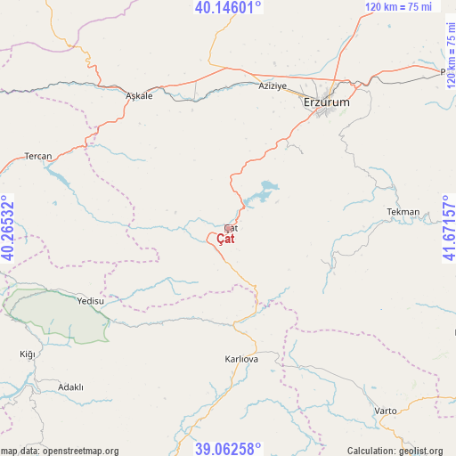
Çat GPS coordinates[2]
39° 36' 23.076" North, 40° 58' 6.384" East
| Map corner | latitude | longitude |
|---|---|---|
| Upper-left | 40.14601°, | 40.26532° |
| Center: | 39.60641°, | 40.96844° |
| Lower-right: | 39.06258°, | 41.67157° |
| Map W x H: | 120.5×120.5 km | = 74.9×74.9mi |
| max Lat: | 42.02683° ⇑36.9% North |
| Çat: | 39.60641° |
| min Lat: | ⇓63.1% South 35.9025° |
| min Long | Çat | max Long |
| 25.90902° | 40.96844° | 44.60099° |
| W 81%⇐ | ⇒19% E |
Elevation
Elevation of Çat is 1894 m = 6214 ft, and this is 1176.6 m = 3860 ft above average elevation for this country.
| Max E: |
2682 m = 8799 ft | 1.7% |
| Çat | 1894 m 6214 ft | |
| Avg. | 717.4 m = 2354 ft | |
Min E: |
0 m = 0 ft | 98.3% |
See also: Turkey elevation on elevation.city.
Geographical zone
Çat is located in North temperate zone (between Tropic of Cancer and the Arctic Circle). Distance of this Northern Tropic circle is 1797.9 km =1117.2 mi to South.| Distance of | km | miles | from Çat |
|---|---|---|---|
| North Pole | 5603.2 | 3481.7 | to North |
| Arctic Circle | 2997.4 | 1862.5 | to North |
| Tropic Cancer | 1797.9 | 1117.2 | to South |
| Equator | 4403.8 | 2736.4 | to South |


Nearby cities:
15 places around Çat: (largest is in red/bold)
• Aşkale
42.1 km =26.2 mi,  326°
326°
• Dadaşköy
44.9 km =27.9 mi,  33°
33°
• Erzurum
42.7 km =26.5 mi,  38°
38°
• Gökoğlan
29.5 km =18.3 mi,  103°
103°
• Göynük
52.5 km =32.6 mi,  188°
188°
• Ilıca
39.3 km =24.4 mi,  15°
15°
• Kandilli
35.2 km =21.9 mi,  341°
341°
• Karlıova
35.3 km =21.9 mi,  174°
174°
• Kazımkarabekir
43.6 km =27.1 mi, 37°
• Palandöken
41.2 km =25.6 mi, 40°
• Tekman
46.2 km =28.7 mi,  85°
85°
• Yakutiye
41.4 km =25.7 mi, 38°
• Yedisu
42 km =26.1 mi,  242°
242°
• Çaylar
46.4 km =28.8 mi,  144°
144°
• Çiftlik
34.6 km =21.5 mi,  304°
304°
Sources, notices
• [Note1] Compared only with cities in Turkey existing in our database
• [Src1] Map data: © OpenStreetMap contributors (CC-BY-SA)
• [Src2] Other city data from geonames.org with taken over terms of usage.
• [Src3] Geographical zone / Annual Mean Temperature by Robert A. Rohde @ Wikipedia
