Dumlu geodata
Dumlu (Erzurum) is a seat of a third-order administrative division; located in Turkey in Europe/Istanbul (GMT+3) time zone. In our database, there are 1323 cities with bigger population. Compared to other cities in Turkey, 70.2% of cities are located further ↓South; 84.9% of cities are located further ←West and 96.7% of cities have lower elevation than Dumlu. Note1


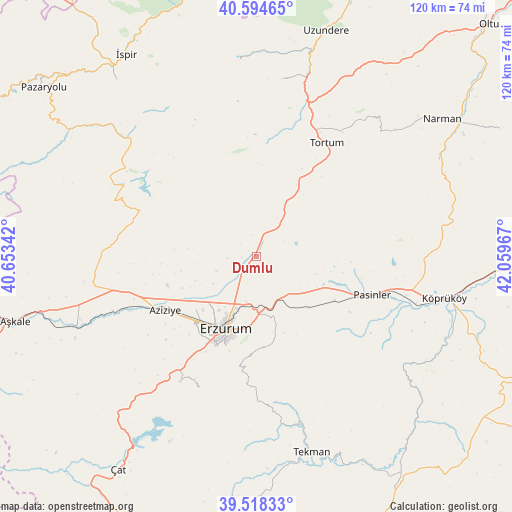
Dumlu GPS coordinates[2]
40° 3' 31.032" North, 41° 21' 23.544" East
| Map corner | latitude | longitude |
|---|---|---|
| Upper-left | 40.59465°, | 40.65342° |
| Center: | 40.05862°, | 41.35654° |
| Lower-right: | 39.51833°, | 42.05967° |
| Map W x H: | 119.7×119.7 km | = 74.4×74.4mi |
| max Lat: | 42.02683° ⇑29.8% North |
| Dumlu: | 40.05862° |
| min Lat: | ⇓70.2% South 35.9025° |
| min Long | Dumlu | max Long |
| 25.90902° | 41.35654° | 44.60099° |
| W 84.9%⇐ | ⇒15.1% E |
Elevation
Elevation of Dumlu is 1778 m = 5833 ft, and this is 1060.6 m = 3480 ft above average elevation for this country.
| Max E: |
2682 m = 8799 ft | 3.3% |
| Dumlu | 1778 m 5833 ft | |
| Avg. | 717.4 m = 2354 ft | |
Min E: |
0 m = 0 ft | 96.7% |
See also: Turkey elevation on elevation.city.
Geographical zone
Dumlu is located in North temperate zone (between Tropic of Cancer and the Arctic Circle). Distance of this Northern Tropic circle is 1848.2 km =1148.4 mi to South.| Distance of | km | miles | from Dumlu |
|---|---|---|---|
| North Pole | 5553 | 3450.5 | to North |
| Arctic Circle | 2947.1 | 1831.2 | to North |
| Tropic Cancer | 1848.2 | 1148.4 | to South |
| Equator | 4454.1 | 2767.6 | to South |


Nearby cities:
15 places around Dumlu: (largest is in red/bold)
• Dadaşköy
15.3 km =9.5 mi,  214°
214°
• Erzurum
18 km =11.2 mi,  202°
202°
• Ilıca
25.5 km =15.8 mi,  240°
240°
• Kandilli
47.4 km =29.5 mi,  249°
249°
• Kazımkarabekir
17.1 km =10.6 mi, 201°
• Köprüköy
44.8 km =27.8 mi,  103°
103°
• Kırık
47.8 km =29.7 mi,  308°
308°
• Ovacık
34.4 km =21.4 mi,  297°
297°
• Palandöken
19.9 km =12.4 mi, 198°
• Pasinler
28.1 km =17.5 mi,  108°
108°
• Söylemez
50.4 km =31.3 mi,  131°
131°
• Tekman
48.1 km =29.9 mi,  164°
164°
• Tortum
30 km =18.6 mi,  31°
31°
• Yakutiye
19.3 km =12 mi, 202°
• Şenyurt
41.3 km =25.7 mi,  8°
8°
Sources, notices
• [Note1] Compared only with cities in Turkey existing in our database
• [Src1] Map data: © OpenStreetMap contributors (CC-BY-SA)
• [Src2] Other city data from geonames.org with taken over terms of usage.
• [Src3] Geographical zone / Annual Mean Temperature by Robert A. Rohde @ Wikipedia
