Taraksu geodata
Taraksu (Adıyaman) is a seat of a third-order administrative division; located in Turkey in Europe/Istanbul (GMT+3) time zone. In our database, there are 1323 cities with bigger population. Compared to other cities in Turkey, 61.1% of cities are located further ↑North; 68.5% of cities are located further ←West and 54.5% of cities have higher elevation than Taraksu. Note1


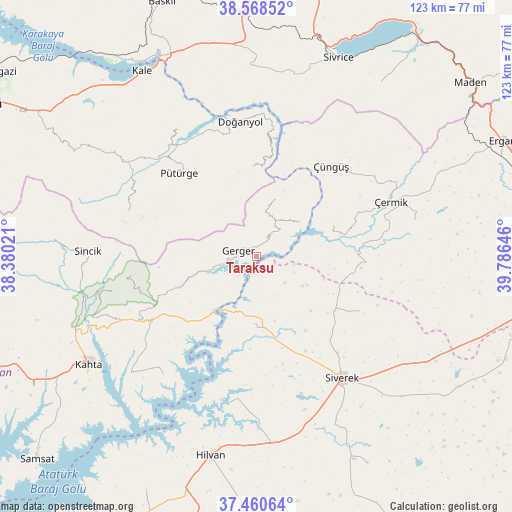
Taraksu GPS coordinates[2]
38° 1' 0.012" North, 39° 4' 59.988" East
| Map corner | latitude | longitude |
|---|---|---|
| Upper-left | 38.56852°, | 38.38021° |
| Center: | 38.01667°, | 39.08333° |
| Lower-right: | 37.46064°, | 39.78646° |
| Map W x H: | 123.2×123.2 km | = 76.6×76.6mi |
| max Lat: | 42.02683° ⇑61.1% North |
| Taraksu: | 38.01667° |
| min Lat: | ⇓38.9% South 35.9025° |
| min Long | Taraksu | max Long |
| 25.90902° | 39.08333° | 44.60099° |
| W 68.5%⇐ | ⇒31.5% E |
Elevation
Elevation of Taraksu is 603 m = 1978 ft, and this is 114.4 m = 375 ft below average elevation for this country.
| Max E: |
2682 m = 8799 ft | 54.5% |
| Avg. | 717.4 m = 2354 ft | |
| Taraksu | 603 m = 1978 ft | |
Min E: |
0 m = 0 ft | 45.5% |
See also: Turkey elevation on elevation.city.
Geographical zone
Taraksu is located in North temperate zone (between Tropic of Cancer and the Arctic Circle). Distance of this Northern Tropic circle is 1621.1 km =1007.3 mi to South.| Distance of | km | miles | from Taraksu |
|---|---|---|---|
| North Pole | 5780 | 3591.5 | to North |
| Arctic Circle | 3174.1 | 1972.3 | to North |
| Tropic Cancer | 1621.1 | 1007.3 | to South |
| Equator | 4227.1 | 2626.6 | to South |


Nearby cities:
15 places around Taraksu: (largest is in red/bold)
• Akıncılar
36.2 km =22.5 mi,  219°
219°
• Bucak
16.5 km =10.3 mi,  186°
186°
• Doğanyol
32.6 km =20.3 mi,  352°
352°
• Gerger
4.5 km =2.8 mi,  286°
286°
• Gerger
9.4 km =5.8 mi, 218°
• Karahan
25.6 km =15.9 mi,  120°
120°
• Narince
32.1 km =19.9 mi,  242°
242°
• Pütürge
28 km =17.4 mi,  316°
316°
• Siverek
35.6 km =22.1 mi,  144°
144°
• Taraksu
16.3 km =10.1 mi,  20°
20°
• Tepehan
33.2 km =20.6 mi, 289°
• Yoğun
38.7 km =24 mi,  76°
76°
• Çaylarbaşı
35.8 km =22.2 mi, 190°
• Çermik
34.3 km =21.3 mi,  67°
67°
• Çüngüş
27.7 km =17.2 mi,  39°
39°
Sources, notices
• [Note1] Compared only with cities in Turkey existing in our database
• [Src1] Map data: © OpenStreetMap contributors (CC-BY-SA)
• [Src2] Other city data from geonames.org with taken over terms of usage.
• [Src3] Geographical zone / Annual Mean Temperature by Robert A. Rohde @ Wikipedia
