Pütürge geodata
Pütürge (Malatya) is a seat of a second-order administrative division; located in Turkey in Europe/Istanbul (GMT+3) time zone. In our database, there are 1323 cities with bigger population. Compared to other cities in Turkey, 58.1% of cities are located further ↑North; 66.4% of cities are located further ←West and 80.6% of cities have lower elevation than Pütürge. Note1


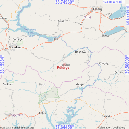
Pütürge GPS coordinates[2]
38° 11' 57.228" North, 38° 51' 46.656" East
| Map corner | latitude | longitude |
|---|---|---|
| Upper-left | 38.74969°, | 38.15984° |
| Center: | 38.19923°, | 38.86296° |
| Lower-right: | 37.64458°, | 39.56609° |
| Map W x H: | 122.9×122.9 km | = 76.4×76.4mi |
| max Lat: | 42.02683° ⇑58.1% North |
| Pütürge: | 38.19923° |
| min Lat: | ⇓41.9% South 35.9025° |
| min Long | Pütürge | max Long |
| 25.90902° | 38.86296° | 44.60099° |
| W 66.4%⇐ | ⇒33.6% E |
Elevation
Elevation of Pütürge is 1205 m = 3953 ft, and this is 487.6 m = 1600 ft above average elevation for this country.
| Max E: |
2682 m = 8799 ft | 19.4% |
| Pütürge | 1205 m 3953 ft | |
| Avg. | 717.4 m = 2354 ft | |
Min E: |
0 m = 0 ft | 80.6% |
See also: Turkey elevation on elevation.city.
Geographical zone
Pütürge is located in North temperate zone (between Tropic of Cancer and the Arctic Circle). Distance of this Northern Tropic circle is 1641.4 km =1019.9 mi to South.| Distance of | km | miles | from Pütürge |
|---|---|---|---|
| North Pole | 5759.7 | 3578.9 | to North |
| Arctic Circle | 3153.8 | 1959.7 | to North |
| Tropic Cancer | 1641.4 | 1019.9 | to South |
| Equator | 4247.4 | 2639.2 | to South |


Nearby cities:
15 places around Pütürge: (largest is in red/bold)
• Damlacık
36.6 km =22.7 mi,  210°
210°
• Doğanyol
19.2 km =11.9 mi,  51°
51°
• Gerger
24.2 km =15 mi,  141°
141°
• Gerger
30.8 km =19.1 mi,  154°
154°
• Gözeli
30.3 km =18.8 mi,  34°
34°
• Kale
25.3 km =15.7 mi,  341°
341°
• Kuşsarayı
32.3 km =20.1 mi,  330°
330°
• Narince
36.4 km =22.6 mi,  194°
194°
• Sincik
28.4 km =17.6 mi,  230°
230°
• Taraksu
25.4 km =15.8 mi,  101°
101°
• Taraksu
28 km =17.4 mi, 136°
• Tepehan
15 km =9.3 mi, 232°
• Yarpuzlu
34 km =21.1 mi,  241°
241°
• Çolaklı
33.5 km =20.8 mi,  296°
296°
• Çüngüş
36.9 km =22.9 mi,  88°
88°
Sources, notices
• [Note1] Compared only with cities in Turkey existing in our database
• [Src1] Map data: © OpenStreetMap contributors (CC-BY-SA)
• [Src2] Other city data from geonames.org with taken over terms of usage.
• [Src3] Geographical zone / Annual Mean Temperature by Robert A. Rohde @ Wikipedia
