Narince geodata
Narince (Adıyaman) is a seat of a third-order administrative division; located in Turkey in Europe/Istanbul (GMT+3) time zone. In our database, there are 1323 cities with bigger population. Compared to other cities in Turkey, 65.9% of cities are located further ↑North; 65.6% of cities are located further ←West and 58.1% of cities have lower elevation than Narince. Note1


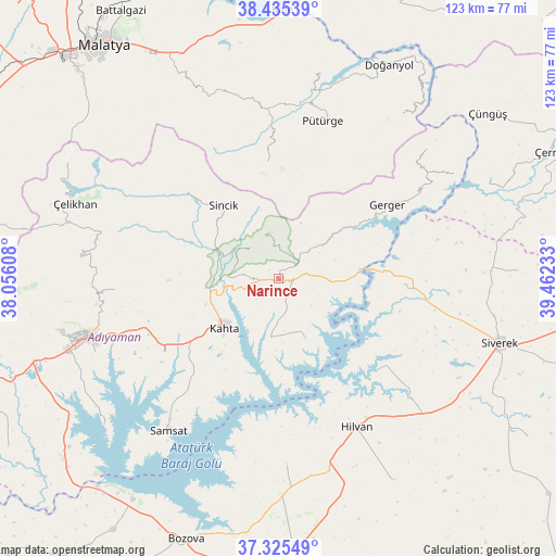
Narince GPS coordinates[2]
37° 52' 57.108" North, 38° 45' 33.12" East
| Map corner | latitude | longitude |
|---|---|---|
| Upper-left | 38.43539°, | 38.05608° |
| Center: | 37.88253°, | 38.7592° |
| Lower-right: | 37.32549°, | 39.46233° |
| Map W x H: | 123.4×123.4 km | = 76.7×76.7mi |
| max Lat: | 42.02683° ⇑65.9% North |
| Narince: | 37.88253° |
| min Lat: | ⇓34.1% South 35.9025° |
| min Long | Narince | max Long |
| 25.90902° | 38.7592° | 44.60099° |
| W 65.6%⇐ | ⇒34.4% E |
Elevation
Elevation of Narince is 846 m = 2776 ft, and this is 128.6 m = 422 ft above average elevation for this country.
| Max E: |
2682 m = 8799 ft | 41.9% |
| Narince | 846 m 2776 ft | |
| Avg. | 717.4 m = 2354 ft | |
Min E: |
0 m = 0 ft | 58.1% |
See also: Turkey elevation on elevation.city.
Geographical zone
Narince is located in North temperate zone (between Tropic of Cancer and the Arctic Circle). Distance of this Northern Tropic circle is 1606.2 km =998 mi to South.| Distance of | km | miles | from Narince |
|---|---|---|---|
| North Pole | 5794.9 | 3600.8 | to North |
| Arctic Circle | 3189 | 1981.6 | to North |
| Tropic Cancer | 1606.2 | 998 | to South |
| Equator | 4212.1 | 2617.3 | to South |


Nearby cities:
15 places around Narince: (largest is in red/bold)
• Akıncılar
14.3 km =8.9 mi,  156°
156°
• Bucak
26.6 km =16.5 mi,  93°
93°
• Damlacık
9.9 km =6.2 mi,  290°
290°
• Gerger
23.8 km =14.8 mi,  71°
71°
• Gerger
29 km =18 mi,  56°
56°
• Hilvan
37.1 km =23.1 mi,  152°
152°
• Kuyucak
36.5 km =22.7 mi,  266°
266°
• Kâhta
16.1 km =10 mi,  227°
227°
• Ovacık
41.1 km =25.5 mi,  177°
177°
• Pütürge
36.4 km =22.6 mi,  14°
14°
• Sincik
21.4 km =13.3 mi,  323°
323°
• Taraksu
32.1 km =19.9 mi, 62°
• Tepehan
26.3 km =16.3 mi,  353°
353°
• Yarpuzlu
28.3 km =17.6 mi,  312°
312°
• Çaylarbaşı
29.9 km =18.6 mi,  132°
132°
Sources, notices
• [Note1] Compared only with cities in Turkey existing in our database
• [Src1] Map data: © OpenStreetMap contributors (CC-BY-SA)
• [Src2] Other city data from geonames.org with taken over terms of usage.
• [Src3] Geographical zone / Annual Mean Temperature by Robert A. Rohde @ Wikipedia
