Bucak geodata
Bucak (Şanlıurfa) is a seat of a third-order administrative division; located in Turkey in Europe/Istanbul (GMT+3) time zone. In our database, there are 1323 cities with bigger population. Compared to other cities in Turkey, 66.3% of cities are located further ↑North; 68.3% of cities are located further ←West and 50.2% of cities have higher elevation than Bucak. Note1


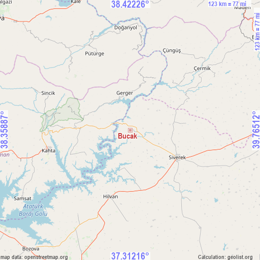
Bucak GPS coordinates[2]
37° 52' 9.48" North, 39° 3' 43.164" East
| Map corner | latitude | longitude |
|---|---|---|
| Upper-left | 38.42226°, | 38.35887° |
| Center: | 37.8693°, | 39.06199° |
| Lower-right: | 37.31216°, | 39.76512° |
| Map W x H: | 123.4×123.4 km | = 76.7×76.7mi |
| max Lat: | 42.02683° ⇑66.3% North |
| Bucak: | 37.8693° |
| min Lat: | ⇓33.7% South 35.9025° |
| min Long | Bucak | max Long |
| 25.90902° | 39.06199° | 44.60099° |
| W 68.3%⇐ | ⇒31.7% E |
Elevation
Elevation of Bucak is 690 m = 2264 ft, and this is 27.4 m = 90 ft below average elevation for this country.
| Max E: |
2682 m = 8799 ft | 50.2% |
| Avg. | 717.4 m = 2354 ft | |
| Bucak | 690 m = 2264 ft | |
Min E: |
0 m = 0 ft | 49.8% |
See also: Turkey elevation on elevation.city.
Geographical zone
Bucak is located in North temperate zone (between Tropic of Cancer and the Arctic Circle). Distance of this Northern Tropic circle is 1604.8 km =997.2 mi to South.| Distance of | km | miles | from Bucak |
|---|---|---|---|
| North Pole | 5796.4 | 3601.7 | to North |
| Arctic Circle | 3190.5 | 1982.5 | to North |
| Tropic Cancer | 1604.8 | 997.2 | to South |
| Equator | 4210.7 | 2616.4 | to South |


Nearby cities:
15 places around Bucak: (largest is in red/bold)
• Akıncılar
24 km =14.9 mi,  240°
240°
• Damlacık
36.2 km =22.5 mi,  277°
277°
• Gerger
9.8 km =6.1 mi,  336°
336°
• Gerger
17.8 km =11.1 mi,  352°
352°
• Hilvan
32.8 km =20.4 mi,  196°
196°
• Karahan
24.1 km =15 mi,  82°
82°
• Kâhta
39.6 km =24.6 mi,  256°
256°
• Narince
26.6 km =16.5 mi,  273°
273°
• Pütürge
40.6 km =25.2 mi,  334°
334°
• Siverek
25.7 km =16 mi,  119°
119°
• Taraksu
16.5 km =10.3 mi,  6°
6°
• Taraksu
32.6 km =20.3 mi, 13°
• Tepehan
40.4 km =25.1 mi,  313°
313°
• Çaylarbaşı
19.4 km =12.1 mi,  193°
193°
• Çüngüş
42.4 km =26.3 mi,  27°
27°
Sources, notices
• [Note1] Compared only with cities in Turkey existing in our database
• [Src1] Map data: © OpenStreetMap contributors (CC-BY-SA)
• [Src2] Other city data from geonames.org with taken over terms of usage.
• [Src3] Geographical zone / Annual Mean Temperature by Robert A. Rohde @ Wikipedia
