Bilecik geodata
Bilecik is a seat of a first-order administrative division; located in Turkey in Europe/Istanbul (GMT+3) time zone. With population of 40,285 people, there are 203 cities with bigger population in this country. Compared to other cities in Turkey, 71.5% of cities are located further ↓South; 75.9% of cities are located further →East and 59.5% of cities have higher elevation than Bilecik. Note1


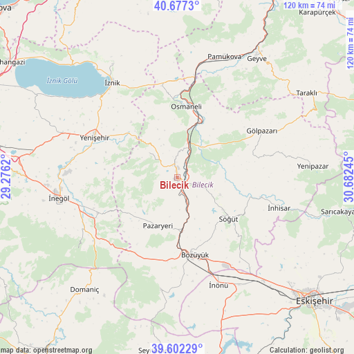
Bilecik GPS coordinates[2]
40° 8' 30.912" North, 29° 58' 45.552" East
| Map corner | latitude | longitude |
|---|---|---|
| Upper-left | 40.6773°, | 29.2762° |
| Center: | 40.14192°, | 29.97932° |
| Lower-right: | 39.60229°, | 30.68245° |
| Map W x H: | 119.5×119.5 km | = 74.3×74.3mi |
| max Lat: | 42.02683° ⇑28.5% North |
| Bilecik: | 40.14192° |
| min Lat: | ⇓71.5% South 35.9025° |
| min Long | Bilecik | max Long |
| 25.90902° | 29.97932° | 44.60099° |
| W 24.1%⇐ | ⇒75.9% E |
Elevation
Elevation of Bilecik is 517 m = 1696 ft, and this is 200.4 m = 657 ft below average elevation for this country.
| Max E: |
2682 m = 8799 ft | 59.5% |
| Avg. | 717.4 m = 2354 ft | |
| Bilecik | 517 m = 1696 ft | |
Min E: |
0 m = 0 ft | 40.5% |
See also: Bilecik elevation on elevation.city.
Geographical zone
Bilecik is located in North temperate zone (between Tropic of Cancer and the Arctic Circle). Distance of this Northern Tropic circle is 1857.4 km =1154.1 mi to South.| Distance of | km | miles | from Bilecik |
|---|---|---|---|
| North Pole | 5543.7 | 3444.7 | to North |
| Arctic Circle | 2937.8 | 1825.5 | to North |
| Tropic Cancer | 1857.4 | 1154.1 | to South |
| Equator | 4463.4 | 2773.4 | to South |


Nearby cities:
15 places around Bilecik: (largest is in red/bold)
• Bozüyük
26.5 km =16.5 mi,  169°
169°
• Dodurga
38.4 km =23.9 mi,  187°
187°
• Dırazali
36.5 km =22.7 mi,  320°
320°
• Gölpazarı
32.8 km =20.4 mi,  61°
61°
• Kaynarca
33 km =20.5 mi,  336°
336°
• Kurşunlu
29.6 km =18.4 mi,  246°
246°
• Küplü
5.2 km =3.2 mi,  159°
159°
• Osmaneli
24.1 km =15 mi,  7°
7°
• Pazaryeri
17.6 km =10.9 mi,  201°
201°
• Söğüt
22.5 km =14 mi,  129°
129°
• Tahtaköprü
35.2 km =21.9 mi,  232°
232°
• Vezirhan
11.9 km =7.4 mi,  16°
16°
• Yarhisar
12.4 km =7.7 mi,  312°
312°
• Yenişehir
30.9 km =19.2 mi,  296°
296°
• İnhisar
36 km =22.4 mi,  106°
106°
Sources, notices
• [Note1] Compared only with cities in Turkey existing in our database
• [Src1] Map data: © OpenStreetMap contributors (CC-BY-SA)
• [Src2] Other city data from geonames.org with taken over terms of usage.
• [Src3] Geographical zone / Annual Mean Temperature by Robert A. Rohde @ Wikipedia
