Süleymanlı geodata
Süleymanlı (Kahramanmaraş) is a seat of a third-order administrative division; located in Turkey in Europe/Istanbul (GMT+3) time zone. In our database, there are 1323 cities with bigger population. Compared to other cities in Turkey, 66.1% of cities are located further ↑North; 56.1% of cities are located further ←West and 76.9% of cities have lower elevation than Süleymanlı. Note1


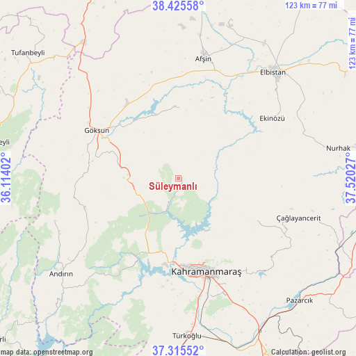
Süleymanlı GPS coordinates[2]
37° 52' 21.504" North, 36° 49' 1.704" East
| Map corner | latitude | longitude |
|---|---|---|
| Upper-left | 38.42558°, | 36.11402° |
| Center: | 37.87264°, | 36.81714° |
| Lower-right: | 37.31552°, | 37.52027° |
| Map W x H: | 123.4×123.4 km | = 76.7×76.7mi |
| max Lat: | 42.02683° ⇑66.1% North |
| Süleymanlı: | 37.87264° |
| min Lat: | ⇓33.9% South 35.9025° |
| min Long | Süleymanlı | max Long |
| 25.90902° | 36.81714° | 44.60099° |
| W 56.1%⇐ | ⇒43.9% E |
Elevation
Elevation of Süleymanlı is 1137 m = 3730 ft, and this is 419.6 m = 1377 ft above average elevation for this country.
| Max E: |
2682 m = 8799 ft | 23.1% |
| Süleymanlı | 1137 m 3730 ft | |
| Avg. | 717.4 m = 2354 ft | |
Min E: |
0 m = 0 ft | 76.9% |
See also: Turkey elevation on elevation.city.
Geographical zone
Süleymanlı is located in North temperate zone (between Tropic of Cancer and the Arctic Circle). Distance of this Northern Tropic circle is 1605.1 km =997.4 mi to South.| Distance of | km | miles | from Süleymanlı |
|---|---|---|---|
| North Pole | 5796 | 3601.5 | to North |
| Arctic Circle | 3190.1 | 1982.2 | to North |
| Tropic Cancer | 1605.1 | 997.4 | to South |
| Equator | 4211 | 2616.6 | to South |


Nearby cities:
15 places around Süleymanlı: (largest is in red/bold)
• Afşin
42.6 km =26.5 mi,  11°
11°
• Andırın
52.2 km =32.4 mi,  231°
231°
• Ağabeyli
30.5 km =19 mi,  120°
120°
• Celeyke
38.6 km =24 mi,  57°
57°
• Elbistan
49.9 km =31 mi,  42°
42°
• Göksun
32.5 km =20.2 mi,  300°
300°
• Kahramanmaraş
33.4 km =20.8 mi,  163°
163°
• Narlı
60.4 km =37.5 mi,  152°
152°
• Nurhak
55.6 km =34.5 mi,  79°
79°
• Pazarcık
60.4 km =37.5 mi,  135°
135°
• Türkoğlu
54.1 km =33.6 mi,  177°
177°
• Yenicekale
34.5 km =21.4 mi,  208°
208°
• Çardak
24.4 km =15.2 mi,  1°
1°
• Çağlayancerit
43.6 km =27.1 mi,  108°
108°
• Çokak
45.5 km =28.3 mi,  250°
250°
Sources, notices
• [Note1] Compared only with cities in Turkey existing in our database
• [Src1] Map data: © OpenStreetMap contributors (CC-BY-SA)
• [Src2] Other city data from geonames.org with taken over terms of usage.
• [Src3] Geographical zone / Annual Mean Temperature by Robert A. Rohde @ Wikipedia
