Nurhak geodata
Nurhak (Kahramanmaraş) is a seat of a second-order administrative division; located in Turkey in Europe/Istanbul (GMT+3) time zone. With population of 8,595 people, there are 549 cities with bigger population in this country. Compared to other cities in Turkey, 62.4% of cities are located further ↑North; 58.4% of cities are located further ←West and 87.5% of cities have lower elevation than Nurhak. Note1


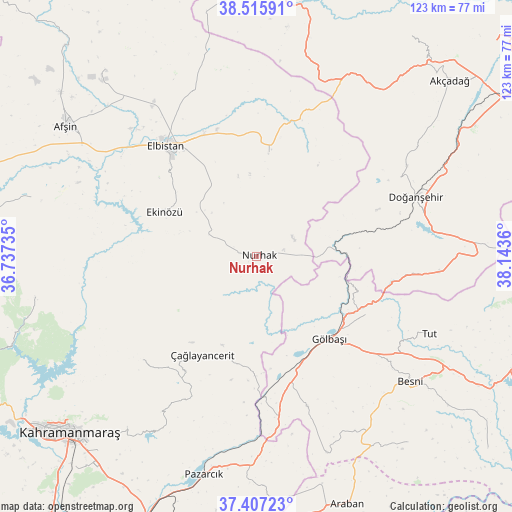
Nurhak GPS coordinates[2]
37° 57' 49.176" North, 37° 26' 25.692" East
| Map corner | latitude | longitude |
|---|---|---|
| Upper-left | 38.51591°, | 36.73735° |
| Center: | 37.96366°, | 37.44047° |
| Lower-right: | 37.40723°, | 38.1436° |
| Map W x H: | 123.3×123.3 km | = 76.6×76.6mi |
| max Lat: | 42.02683° ⇑62.4% North |
| Nurhak: | 37.96366° |
| min Lat: | ⇓37.6% South 35.9025° |
| min Long | Nurhak | max Long |
| 25.90902° | 37.44047° | 44.60099° |
| W 58.4%⇐ | ⇒41.6% E |
Elevation
Elevation of Nurhak is 1384 m = 4541 ft, and this is 666.6 m = 2187 ft above average elevation for this country.
| Max E: |
2682 m = 8799 ft | 12.5% |
| Nurhak | 1384 m 4541 ft | |
| Avg. | 717.4 m = 2354 ft | |
Min E: |
0 m = 0 ft | 87.5% |
See also: Turkey elevation on elevation.city.
Geographical zone
Nurhak is located in North temperate zone (between Tropic of Cancer and the Arctic Circle). Distance of this Northern Tropic circle is 1615.2 km =1003.6 mi to South.| Distance of | km | miles | from Nurhak |
|---|---|---|---|
| North Pole | 5785.9 | 3595.2 | to North |
| Arctic Circle | 3180 | 1976 | to North |
| Tropic Cancer | 1615.2 | 1003.6 | to South |
| Equator | 4221.2 | 2622.9 | to South |


Nearby cities:
15 places around Nurhak: (largest is in red/bold)
• Ağabeyli
38.3 km =23.8 mi,  228°
228°
• Belören
38.3 km =23.8 mi,  161°
161°
• Besni
47.7 km =29.6 mi,  129°
129°
• Celeyke
24.6 km =15.3 mi,  295°
295°
• Doğanşehir
40.1 km =24.9 mi,  70°
70°
• Elbistan
34.3 km =21.3 mi,  321°
321°
• Gölbaşı
26.4 km =16.4 mi,  139°
139°
• Gücük
25.8 km =16 mi,  7°
7°
• Harmanlı
30.1 km =18.7 mi,  117°
117°
• Kürecik
49.1 km =30.5 mi,  32°
32°
• Pazarcık
54.4 km =33.8 mi,  193°
193°
• Suvarlı
50.2 km =31.2 mi, 160°
• Sürgü
46.1 km =28.6 mi,  84°
84°
• Tut
45.7 km =28.4 mi,  114°
114°
• Çağlayancerit
27.8 km =17.3 mi,  209°
209°
Sources, notices
• [Note1] Compared only with cities in Turkey existing in our database
• [Src1] Map data: © OpenStreetMap contributors (CC-BY-SA)
• [Src2] Other city data from geonames.org with taken over terms of usage.
• [Src3] Geographical zone / Annual Mean Temperature by Robert A. Rohde @ Wikipedia
