Afşin geodata
Afşin (Kahramanmaraş) is a seat of a second-order administrative division; located in Turkey in Europe/Istanbul (GMT+3) time zone. With population of 39,613 people, there are 204 cities with bigger population in this country. Compared to other cities in Turkey, 57.2% of cities are located further ↑North; 56.4% of cities are located further ←West and 81.5% of cities have lower elevation than Afşin. Note1


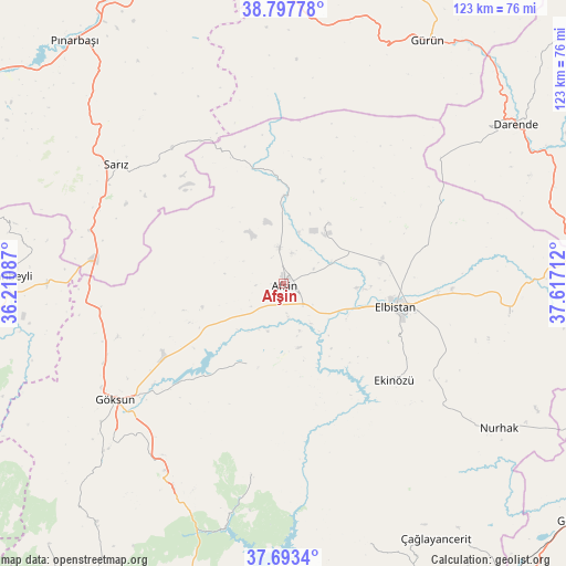
Afşin GPS coordinates[2]
38° 14' 51.684" North, 36° 54' 50.364" East
| Map corner | latitude | longitude |
|---|---|---|
| Upper-left | 38.79778°, | 36.21087° |
| Center: | 38.24769°, | 36.91399° |
| Lower-right: | 37.6934°, | 37.61712° |
| Map W x H: | 122.8×122.8 km | = 76.3×76.3mi |
| max Lat: | 42.02683° ⇑57.2% North |
| Afşin: | 38.24769° |
| min Lat: | ⇓42.8% South 35.9025° |
| min Long | Afşin | max Long |
| 25.90902° | 36.91399° | 44.60099° |
| W 56.4%⇐ | ⇒43.6% E |
Elevation
Elevation of Afşin is 1222 m = 4009 ft, and this is 504.6 m = 1656 ft above average elevation for this country.
| Max E: |
2682 m = 8799 ft | 18.5% |
| Afşin | 1222 m 4009 ft | |
| Avg. | 717.4 m = 2354 ft | |
Min E: |
0 m = 0 ft | 81.5% |
See also: Turkey elevation on elevation.city.
Geographical zone
Afşin is located in North temperate zone (between Tropic of Cancer and the Arctic Circle). Distance of this Northern Tropic circle is 1646.8 km =1023.3 mi to South.| Distance of | km | miles | from Afşin |
|---|---|---|---|
| North Pole | 5754.3 | 3575.6 | to North |
| Arctic Circle | 3148.4 | 1956.3 | to North |
| Tropic Cancer | 1646.8 | 1023.3 | to South |
| Equator | 4252.7 | 2642.5 | to South |


Nearby cities:
15 places around Afşin: (largest is in red/bold)
• Ağabeyli
59.8 km =37.2 mi,  162°
162°
• Balaban
62.6 km =38.9 mi,  67°
67°
• Celeyke
31.8 km =19.8 mi,  131°
131°
• Darende
61.3 km =38.1 mi,  57°
57°
• Elbistan
25.3 km =15.7 mi,  100°
100°
• Göksun
44.3 km =27.5 mi,  235°
235°
• Gücük
49.9 km =31 mi, 96°
• Gürün
61.2 km =38 mi,  30°
30°
• Nurhak
55.8 km =34.7 mi,  124°
124°
• Sarız
44.4 km =27.6 mi,  305°
305°
• Süleymanlı
42.6 km =26.5 mi,  191°
191°
• Tanır
19.1 km =11.9 mi,  359°
359°
• Tufanbeyli
60.6 km =37.7 mi,  271°
271°
• Yazyurdu
61.3 km =38.1 mi,  1°
1°
• Çardak
19.1 km =11.9 mi,  204°
204°
Sources, notices
• [Note1] Compared only with cities in Turkey existing in our database
• [Src1] Map data: © OpenStreetMap contributors (CC-BY-SA)
• [Src2] Other city data from geonames.org with taken over terms of usage.
• [Src3] Geographical zone / Annual Mean Temperature by Robert A. Rohde @ Wikipedia
