Pazarcık geodata
Pazarcık (Kahramanmaraş) is a populated place; located in Turkey in Europe/Istanbul (GMT+3) time zone. With population of 23,850 people, there are 297 cities with bigger population in this country. Compared to other cities in Turkey, 75.1% of cities are located further ↑North; 57.9% of cities are located further ←West and 54.7% of cities have lower elevation than Pazarcık. Note1


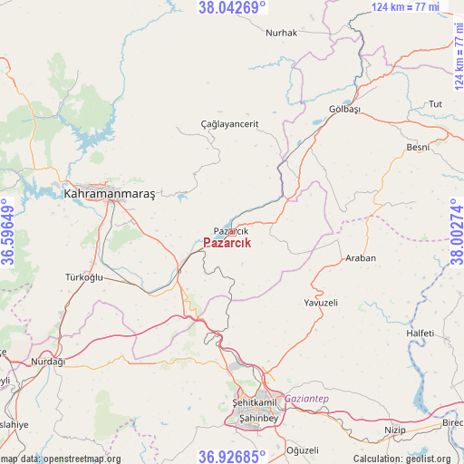
Pazarcık GPS coordinates[2]
37° 29' 12.66" North, 37° 17' 58.596" East
| Map corner | latitude | longitude |
|---|---|---|
| Upper-left | 38.04269°, | 36.59649° |
| Center: | 37.48685°, | 37.29961° |
| Lower-right: | 36.92685°, | 38.00274° |
| Map W x H: | 124.1×124.1 km | = 77.1×77.1mi |
| max Lat: | 42.02683° ⇑75.1% North |
| Pazarcık: | 37.48685° |
| min Lat: | ⇓24.9% South 35.9025° |
| min Long | Pazarcık | max Long |
| 25.90902° | 37.29961° | 44.60099° |
| W 57.9%⇐ | ⇒42.1% E |
Elevation
Elevation of Pazarcık is 787 m = 2582 ft, and this is 69.6 m = 228 ft above average elevation for this country.
| Max E: |
2682 m = 8799 ft | 45.3% |
| Pazarcık | 787 m 2582 ft | |
| Avg. | 717.4 m = 2354 ft | |
Min E: |
0 m = 0 ft | 54.7% |
See also: Turkey elevation on elevation.city.
Geographical zone
Pazarcık is located in North temperate zone (between Tropic of Cancer and the Arctic Circle). Distance of this Northern Tropic circle is 1562.2 km =970.7 mi to South.| Distance of | km | miles | from Pazarcık |
|---|---|---|---|
| North Pole | 5838.9 | 3628.1 | to North |
| Arctic Circle | 3233 | 2008.9 | to North |
| Tropic Cancer | 1562.2 | 970.7 | to South |
| Equator | 4168.1 | 2589.9 | to South |


Nearby cities:
15 places around Pazarcık: (largest is in red/bold)
• Araban
35 km =21.7 mi,  101°
101°
• Ağabeyli
31.8 km =19.8 mi,  329°
329°
• Belören
29.9 km =18.6 mi,  55°
55°
• Gaziantep
48.1 km =29.9 mi,  171°
171°
• Gölbaşı
44.4 km =27.6 mi,  41°
41°
• Kahramanmaraş
34.7 km =21.6 mi,  288°
288°
• Keysun
49.7 km =30.9 mi,  80°
80°
• Narlı
17.9 km =11.1 mi,  233°
233°
• Sakçagöz
48.8 km =30.3 mi,  224°
224°
• Suvarlı
29.9 km =18.6 mi, 78°
• Türkoğlu
41.9 km =26 mi,  254°
254°
• Yavuzeli
30.3 km =18.8 mi,  128°
128°
• Çağlayancerit
28.8 km =17.9 mi,  357°
357°
• Şahinbey
48.9 km =30.4 mi,  175°
175°
• Şehitkamil
45.8 km =28.5 mi, 171°
Sources, notices
• [Note1] Compared only with cities in Turkey existing in our database
• [Src1] Map data: © OpenStreetMap contributors (CC-BY-SA)
• [Src2] Other city data from geonames.org with taken over terms of usage.
• [Src3] Geographical zone / Annual Mean Temperature by Robert A. Rohde @ Wikipedia
