Göksun geodata
Göksun (Kahramanmaraş) is a seat of a second-order administrative division; located in Turkey in Europe/Istanbul (GMT+3) time zone. With population of 34,243 people, there are 229 cities with bigger population in this country. Compared to other cities in Turkey, 61% of cities are located further ↑North; 54.7% of cities are located further ←West and 86.1% of cities have lower elevation than Göksun. Note1


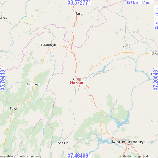
Göksun GPS coordinates[2]
38° 1' 15.456" North, 36° 29' 50.28" East
| Map corner | latitude | longitude |
|---|---|---|
| Upper-left | 38.57277°, | 35.79418° |
| Center: | 38.02096°, | 36.4973° |
| Lower-right: | 37.46496°, | 37.20043° |
| Map W x H: | 123.2×123.2 km | = 76.6×76.6mi |
| max Lat: | 42.02683° ⇑61% North |
| Göksun: | 38.02096° |
| min Lat: | ⇓39% South 35.9025° |
| min Long | Göksun | max Long |
| 25.90902° | 36.4973° | 44.60099° |
| W 54.7%⇐ | ⇒45.3% E |
Elevation
Elevation of Göksun is 1344 m = 4409 ft, and this is 626.6 m = 2056 ft above average elevation for this country.
| Max E: |
2682 m = 8799 ft | 13.9% |
| Göksun | 1344 m 4409 ft | |
| Avg. | 717.4 m = 2354 ft | |
Min E: |
0 m = 0 ft | 86.1% |
See also: Turkey elevation on elevation.city.
Geographical zone
Göksun is located in North temperate zone (between Tropic of Cancer and the Arctic Circle). Distance of this Northern Tropic circle is 1621.6 km =1007.6 mi to South.| Distance of | km | miles | from Göksun |
|---|---|---|---|
| North Pole | 5779.5 | 3591.2 | to North |
| Arctic Circle | 3173.6 | 1972 | to North |
| Tropic Cancer | 1621.6 | 1007.6 | to South |
| Equator | 4227.5 | 2626.8 | to South |


Nearby cities:
15 places around Göksun: (largest is in red/bold)
• Afşin
44.3 km =27.5 mi,  55°
55°
• Andırın
50.9 km =31.6 mi,  194°
194°
• Ağabeyli
63 km =39.1 mi,  120°
120°
• Celeyke
60.6 km =37.7 mi,  85°
85°
• Feke
56.2 km =34.9 mi,  245°
245°
• Kahramanmaraş
61.4 km =38.2 mi,  142°
142°
• Saimbeyli
35.8 km =22.2 mi,  263°
263°
• Sarız
50.9 km =31.6 mi,  0°
0°
• Süleymanlı
32.5 km =20.2 mi, 120°
• Tanır
57.2 km =35.5 mi,  39°
39°
• Toklar
61 km =37.9 mi,  316°
316°
• Tufanbeyli
36.2 km =22.5 mi, 318°
• Yenicekale
48.4 km =30.1 mi,  165°
165°
• Çardak
29.6 km =18.4 mi,  74°
74°
• Çokak
35 km =21.7 mi,  205°
205°
Sources, notices
• [Note1] Compared only with cities in Turkey existing in our database
• [Src1] Map data: © OpenStreetMap contributors (CC-BY-SA)
• [Src2] Other city data from geonames.org with taken over terms of usage.
• [Src3] Geographical zone / Annual Mean Temperature by Robert A. Rohde @ Wikipedia
