Narlı geodata
Narlı (Kahramanmaraş) is a seat of a third-order administrative division; located in Turkey in Europe/Istanbul (GMT+3) time zone. In our database, there are 1323 cities with bigger population. Compared to other cities in Turkey, 77.7% of cities are located further ↑North; 57.2% of cities are located further ←West and 54.8% of cities have higher elevation than Narlı. Note1


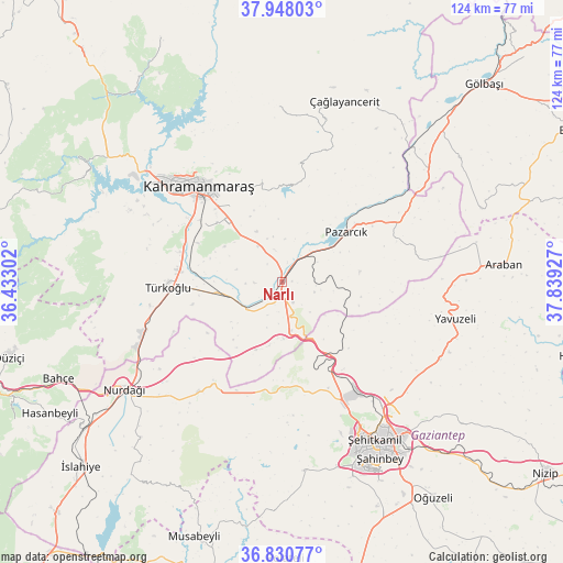
Narlı GPS coordinates[2]
37° 23' 29.328" North, 37° 8' 10.104" East
| Map corner | latitude | longitude |
|---|---|---|
| Upper-left | 37.94803°, | 36.43302° |
| Center: | 37.39148°, | 37.13614° |
| Lower-right: | 36.83077°, | 37.83927° |
| Map W x H: | 124.2×124.2 km | = 77.2×77.2mi |
| max Lat: | 42.02683° ⇑77.7% North |
| Narlı: | 37.39148° |
| min Lat: | ⇓22.3% South 35.9025° |
| min Long | Narlı | max Long |
| 25.90902° | 37.13614° | 44.60099° |
| W 57.2%⇐ | ⇒42.8% E |
Elevation
Elevation of Narlı is 588 m = 1929 ft, and this is 129.4 m = 425 ft below average elevation for this country.
| Max E: |
2682 m = 8799 ft | 54.8% |
| Avg. | 717.4 m = 2354 ft | |
| Narlı | 588 m = 1929 ft | |
Min E: |
0 m = 0 ft | 45.2% |
See also: Turkey elevation on elevation.city.
Geographical zone
Narlı is located in North temperate zone (between Tropic of Cancer and the Arctic Circle). Distance of this Northern Tropic circle is 1551.6 km =964.1 mi to South.| Distance of | km | miles | from Narlı |
|---|---|---|---|
| North Pole | 5849.5 | 3634.7 | to North |
| Arctic Circle | 3243.6 | 2015.5 | to North |
| Tropic Cancer | 1551.6 | 964.1 | to South |
| Equator | 4157.5 | 2583.3 | to South |


Nearby cities:
15 places around Narlı: (largest is in red/bold)
• Araban
49 km =30.4 mi,  85°
85°
• Ağabeyli
38.1 km =23.7 mi,  357°
357°
• Belören
47.8 km =29.7 mi,  55°
55°
• Burç
42.2 km =26.2 mi,  174°
174°
• Gaziantep
42.9 km =26.7 mi,  149°
149°
• Kahramanmaraş
28.4 km =17.6 mi,  319°
319°
• Nurdağı
43.2 km =26.8 mi,  234°
234°
• Pazarcık
17.9 km =11.1 mi,  53°
53°
• Sakçagöz
31.2 km =19.4 mi,  218°
218°
• Suvarlı
46.7 km =29 mi,  69°
69°
• Türkoğlu
25.9 km =16.1 mi,  268°
268°
• Yavuzeli
39.1 km =24.3 mi,  102°
102°
• Çağlayancerit
41.5 km =25.8 mi,  18°
18°
• Şahinbey
42.3 km =26.3 mi, 154°
• Şehitkamil
40.8 km =25.4 mi, 148°
Sources, notices
• [Note1] Compared only with cities in Turkey existing in our database
• [Src1] Map data: © OpenStreetMap contributors (CC-BY-SA)
• [Src2] Other city data from geonames.org with taken over terms of usage.
• [Src3] Geographical zone / Annual Mean Temperature by Robert A. Rohde @ Wikipedia
