Hamzalı geodata
Hamzalı (Diyarbakır) is a seat of a third-order administrative division; located in Turkey in Europe/Istanbul (GMT+3) time zone. In our database, there are 1323 cities with bigger population. Compared to other cities in Turkey, 55.3% of cities are located further ↑North; 82.6% of cities are located further ←West and 71.5% of cities have lower elevation than Hamzalı. Note1


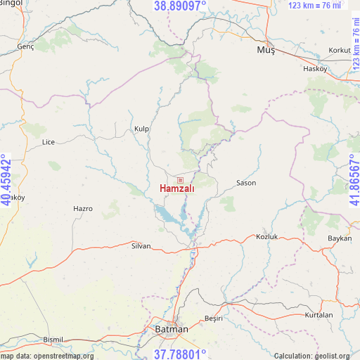
Hamzalı GPS coordinates[2]
38° 20' 29.724" North, 41° 9' 45.144" East
| Map corner | latitude | longitude |
|---|---|---|
| Upper-left | 38.89097°, | 40.45942° |
| Center: | 38.34159°, | 41.16254° |
| Lower-right: | 37.78801°, | 41.86567° |
| Map W x H: | 122.6×122.6 km | = 76.2×76.2mi |
| max Lat: | 42.02683° ⇑55.3% North |
| Hamzalı: | 38.34159° |
| min Lat: | ⇓44.7% South 35.9025° |
| min Long | Hamzalı | max Long |
| 25.90902° | 41.16254° | 44.60099° |
| W 82.6%⇐ | ⇒17.4% E |
Elevation
Elevation of Hamzalı is 1049 m = 3442 ft, and this is 331.6 m = 1088 ft above average elevation for this country.
| Max E: |
2682 m = 8799 ft | 28.5% |
| Hamzalı | 1049 m 3442 ft | |
| Avg. | 717.4 m = 2354 ft | |
Min E: |
0 m = 0 ft | 71.5% |
See also: Turkey elevation on elevation.city.
Geographical zone
Hamzalı is located in North temperate zone (between Tropic of Cancer and the Arctic Circle). Distance of this Northern Tropic circle is 1657.3 km =1029.8 mi to South.| Distance of | km | miles | from Hamzalı |
|---|---|---|---|
| North Pole | 5743.9 | 3569.1 | to North |
| Arctic Circle | 3138 | 1949.9 | to North |
| Tropic Cancer | 1657.3 | 1029.8 | to South |
| Equator | 4263.2 | 2649 | to South |


Nearby cities:
15 places around Hamzalı: (largest is in red/bold)
• Akbaş
41.5 km =25.8 mi,  192°
192°
• Akçasır
14.8 km =9.2 mi,  37°
37°
• Akçayır
41.8 km =26 mi,  201°
201°
• Altınkum
12.3 km =7.6 mi,  225°
225°
• Ağaçlı
29.8 km =18.5 mi,  310°
310°
• Bekirhan
25.1 km =15.6 mi,  152°
152°
• Beyçayırı
39 km =24.2 mi,  158°
158°
• Hazro
35.7 km =22.2 mi,  253°
253°
• Kozluk
32.2 km =20 mi,  121°
121°
• Kulp
22 km =13.7 mi,  321°
321°
• Malabadi
21.4 km =13.3 mi,  170°
170°
• Melefan
39.7 km =24.7 mi, 116°
• Sason
22 km =13.7 mi,  94°
94°
• Silvan
26.4 km =16.4 mi,  210°
210°
• Yücebağ
10.8 km =6.7 mi,  57°
57°
Sources, notices
• [Note1] Compared only with cities in Turkey existing in our database
• [Src1] Map data: © OpenStreetMap contributors (CC-BY-SA)
• [Src2] Other city data from geonames.org with taken over terms of usage.
• [Src3] Geographical zone / Annual Mean Temperature by Robert A. Rohde @ Wikipedia
