Karasüleymanlı geodata
Karasüleymanlı (Hatay) is a populated place; located in Turkey in Europe/Istanbul (GMT+3) time zone. With population of 1,660 people, there are 993 cities with bigger population in this country. Compared to other cities in Turkey, 97.6% of cities are located further ↑North; 54.2% of cities are located further ←West and 82.8% of cities have higher elevation than Karasüleymanlı. Note1


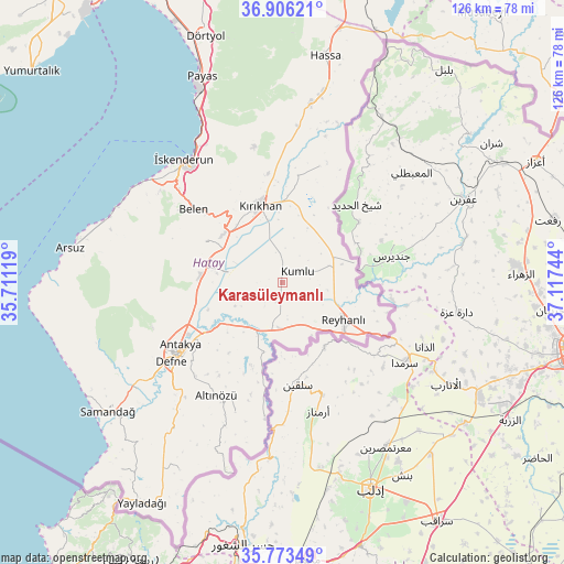
Karasüleymanlı GPS coordinates[2]
36° 20' 30.876" North, 36° 24' 51.516" East
| Map corner | latitude | longitude |
|---|---|---|
| Upper-left | 36.90621°, | 35.71119° |
| Center: | 36.34191°, | 36.41431° |
| Lower-right: | 35.77349°, | 37.11744° |
| Map W x H: | 125.9×125.9 km | = 78.2×78.2mi |
| max Lat: | 42.02683° ⇑97.6% North |
| Karasüleymanlı: | 36.34191° |
| min Lat: | ⇓2.4% South 35.9025° |
| min Long | Karasüleymanl� | max Long |
| 25.90902° | 36.41431° | 44.60099° |
| W 54.2%⇐ | ⇒45.8% E |
Elevation
Elevation of Karasüleymanlı is 87 m = 285 ft, and this is 630.4 m = 2068 ft below average elevation for this country.
| Max E: |
2682 m = 8799 ft | 82.8% |
| Avg. | 717.4 m = 2354 ft | |
| Karasüleymanlı | 87 m = 285 ft | |
Min E: |
0 m = 0 ft | 17.2% |
See also: Turkey elevation on elevation.city.
Geographical zone
Karasüleymanlı is located in North temperate zone (between Tropic of Cancer and the Arctic Circle). Distance of this Northern Tropic circle is 1434.9 km =891.6 mi to South.| Distance of | km | miles | from Karasüleymanlı |
|---|---|---|---|
| North Pole | 5966.2 | 3707.2 | to North |
| Arctic Circle | 3360.3 | 2088 | to North |
| Tropic Cancer | 1434.9 | 891.6 | to South |
| Equator | 4040.8 | 2510.8 | to South |


Nearby cities:
15 places around Karasüleymanlı: (largest is in red/bold)
• Anayazı
20.2 km =12.6 mi,  263°
263°
• Atayurdu
21.6 km =13.4 mi,  214°
214°
• Açıkdere
19.4 km =12.1 mi,  225°
225°
• Belen
25.5 km =15.8 mi,  309°
309°
• Boynuyoğun
20.2 km =12.6 mi,  198°
198°
• Büyük Dalyan
19.3 km =12 mi,  252°
252°
• Kastal
18.7 km =11.6 mi,  235°
235°
• Kumlu
4.4 km =2.7 mi,  56°
56°
• Kuzeytepe
24.9 km =15.5 mi, 249°
• Kırıkhan
18.2 km =11.3 mi,  343°
343°
• Mansurlu
21.3 km =13.2 mi, 230°
• Reyhanlı
16 km =9.9 mi,  120°
120°
• Serinyol
18.1 km =11.2 mi,  276°
276°
• Uzunkavak
1.3 km =0.8 mi,  21°
21°
• Yeşilova
16.5 km =10.3 mi, 240°
Sources, notices
• [Note1] Compared only with cities in Turkey existing in our database
• [Src1] Map data: © OpenStreetMap contributors (CC-BY-SA)
• [Src2] Other city data from geonames.org with taken over terms of usage.
• [Src3] Geographical zone / Annual Mean Temperature by Robert A. Rohde @ Wikipedia
