Kula geodata
Kula (Manisa) is a seat of a second-order administrative division; located in Turkey in Europe/Istanbul (GMT+3) time zone. With population of 31,100 people, there are 245 cities with bigger population in this country. Compared to other cities in Turkey, 52.3% of cities are located further ↑North; 86.1% of cities are located further →East and 51.3% of cities have higher elevation than Kula. Note1


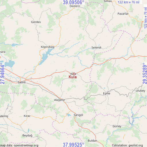
Kula GPS coordinates[2]
38° 32' 50.136" North, 28° 38' 59.136" East
| Map corner | latitude | longitude |
|---|---|---|
| Upper-left | 39.09506°, | 27.94664° |
| Center: | 38.54726°, | 28.64976° |
| Lower-right: | 37.99525°, | 29.35289° |
| Map W x H: | 122.3×122.3 km | = 76×76mi |
| max Lat: | 42.02683° ⇑52.3% North |
| Kula: | 38.54726° |
| min Lat: | ⇓47.7% South 35.9025° |
| min Long | Kula | max Long |
| 25.90902° | 28.64976° | 44.60099° |
| W 13.9%⇐ | ⇒86.1% E |
Elevation
Elevation of Kula is 671 m = 2201 ft, and this is 46.4 m = 152 ft below average elevation for this country.
| Max E: |
2682 m = 8799 ft | 51.3% |
| Avg. | 717.4 m = 2354 ft | |
| Kula | 671 m = 2201 ft | |
Min E: |
0 m = 0 ft | 48.7% |
See also: Turkey elevation on elevation.city.
Geographical zone
Kula is located in North temperate zone (between Tropic of Cancer and the Arctic Circle). Distance of this Northern Tropic circle is 1680.1 km =1044 mi to South.| Distance of | km | miles | from Kula |
|---|---|---|---|
| North Pole | 5721 | 3554.9 | to North |
| Arctic Circle | 3115.1 | 1935.6 | to North |
| Tropic Cancer | 1680.1 | 1044 | to South |
| Equator | 4286.1 | 2663.3 | to South |


Nearby cities:
15 places around Kula: (largest is in red/bold)
• Adala
33.3 km =20.7 mi,  275°
275°
• Alaşehir
24.7 km =15.3 mi,  207°
207°
• Borlu
27.8 km =17.3 mi,  325°
325°
• Eşme
32.3 km =20.1 mi,  120°
120°
• Güllü
50.1 km =31.1 mi,  127°
127°
• Güre
46.4 km =28.8 mi,  75°
75°
• Kiraz
52.4 km =32.6 mi,  227°
227°
• Köprübaşı
31 km =19.3 mi,  316°
316°
• Menye
14.3 km =8.9 mi, 282°
• Salihli
44.3 km =27.5 mi,  260°
260°
• Sarıgöl
34.5 km =21.4 mi,  173°
173°
• Selendi
29 km =18 mi,  40°
40°
• Yarbasan
51 km =31.7 mi,  15°
15°
• Yeşilyurt
23.1 km =14.4 mi,  176°
176°
• İlyaslı
48.3 km =30 mi, 82°
Sources, notices
• [Note1] Compared only with cities in Turkey existing in our database
• [Src1] Map data: © OpenStreetMap contributors (CC-BY-SA)
• [Src2] Other city data from geonames.org with taken over terms of usage.
• [Src3] Geographical zone / Annual Mean Temperature by Robert A. Rohde @ Wikipedia
