Borlu geodata
Borlu (Manisa) is a seat of a third-order administrative division; located in Turkey in Europe/Istanbul (GMT+3) time zone. In our database, there are 1323 cities with bigger population. Compared to other cities in Turkey, 51.3% of cities are located further ↓South; 87.2% of cities are located further →East and 71.2% of cities have higher elevation than Borlu. Note1


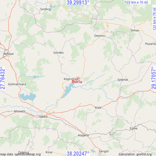
Borlu GPS coordinates[2]
38° 45' 10.476" North, 28° 28' 2.784" East
| Map corner | latitude | longitude |
|---|---|---|
| Upper-left | 39.29913°, | 27.76432° |
| Center: | 38.75291°, | 28.46744° |
| Lower-right: | 38.20247°, | 29.17057° |
| Map W x H: | 121.9×121.9 km | = 75.7×75.7mi |
| max Lat: | 42.02683° ⇑48.7% North |
| Borlu: | 38.75291° |
| min Lat: | ⇓51.3% South 35.9025° |
| min Long | Borlu | max Long |
| 25.90902° | 28.46744° | 44.60099° |
| W 12.8%⇐ | ⇒87.2% E |
Elevation
Elevation of Borlu is 256 m = 840 ft, and this is 461.4 m = 1514 ft below average elevation for this country.
| Max E: |
2682 m = 8799 ft | 71.2% |
| Avg. | 717.4 m = 2354 ft | |
| Borlu | 256 m = 840 ft | |
Min E: |
0 m = 0 ft | 28.8% |
See also: Turkey elevation on elevation.city.
Geographical zone
Borlu is located in North temperate zone (between Tropic of Cancer and the Arctic Circle). Distance of this Northern Tropic circle is 1703 km =1058.2 mi to South.| Distance of | km | miles | from Borlu |
|---|---|---|---|
| North Pole | 5698.1 | 3540.6 | to North |
| Arctic Circle | 3092.3 | 1921.5 | to North |
| Tropic Cancer | 1703 | 1058.2 | to South |
| Equator | 4308.9 | 2677.4 | to South |


Nearby cities:
15 places around Borlu: (largest is in red/bold)
• Adala
26 km =16.2 mi,  221°
221°
• Ahmetli
52.7 km =32.7 mi,  240°
240°
• Akhisar
57.4 km =35.7 mi,  288°
288°
• Alaşehir
44.9 km =27.9 mi,  174°
174°
• Demirci
36.6 km =22.7 mi,  26°
26°
• Düvertepe
53.9 km =33.5 mi,  357°
357°
• Gölmarmara
48.2 km =30 mi,  264°
264°
• Gördes
25.3 km =15.7 mi,  322°
322°
• Kula
27.8 km =17.3 mi,  145°
145°
• Köprübaşı
5.5 km =3.4 mi,  266°
266°
• Menye
19.8 km =12.3 mi, 174°
• Salihli
40.9 km =25.4 mi, 222°
• Selendi
34.7 km =21.6 mi,  91°
91°
• Yarbasan
39.5 km =24.5 mi,  48°
48°
• Yeşilyurt
49 km =30.4 mi,  159°
159°
Sources, notices
• [Note1] Compared only with cities in Turkey existing in our database
• [Src1] Map data: © OpenStreetMap contributors (CC-BY-SA)
• [Src2] Other city data from geonames.org with taken over terms of usage.
• [Src3] Geographical zone / Annual Mean Temperature by Robert A. Rohde @ Wikipedia
