Yeşilyurt geodata
Yeşilyurt (Manisa) is a seat of a third-order administrative division; located in Turkey in Europe/Istanbul (GMT+3) time zone. In our database, there are 1323 cities with bigger population. Compared to other cities in Turkey, 55.3% of cities are located further ↑North; 86% of cities are located further →East and 74.6% of cities have higher elevation than Yeşilyurt. Note1


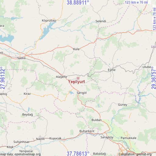
Yeşilyurt GPS coordinates[2]
38° 20' 22.992" North, 28° 39' 51.984" East
| Map corner | latitude | longitude |
|---|---|---|
| Upper-left | 38.88911°, | 27.96132° |
| Center: | 38.33972°, | 28.66444° |
| Lower-right: | 37.78613°, | 29.36757° |
| Map W x H: | 122.6×122.6 km | = 76.2×76.2mi |
| max Lat: | 42.02683° ⇑55.3% North |
| Yeşilyurt: | 38.33972° |
| min Lat: | ⇓44.7% South 35.9025° |
| min Long | Yeşilyurt | max Long |
| 25.90902° | 28.66444° | 44.60099° |
| W 14%⇐ | ⇒86% E |
Elevation
Elevation of Yeşilyurt is 181 m = 594 ft, and this is 536.4 m = 1760 ft below average elevation for this country.
| Max E: |
2682 m = 8799 ft | 74.6% |
| Avg. | 717.4 m = 2354 ft | |
| Yeşilyurt | 181 m = 594 ft | |
Min E: |
0 m = 0 ft | 25.4% |
See also: Turkey elevation on elevation.city.
Geographical zone
Yeşilyurt is located in North temperate zone (between Tropic of Cancer and the Arctic Circle). Distance of this Northern Tropic circle is 1657.1 km =1029.7 mi to South.| Distance of | km | miles | from Yeşilyurt |
|---|---|---|---|
| North Pole | 5744.1 | 3569.2 | to North |
| Arctic Circle | 3138.2 | 1950 | to North |
| Tropic Cancer | 1657.1 | 1029.7 | to South |
| Equator | 4263 | 2648.9 | to South |


Nearby cities:
15 places around Yeşilyurt: (largest is in red/bold)
• Adala
43.5 km =27 mi,  307°
307°
• Alaşehir
12.9 km =8 mi,  275°
275°
• Buharkent
42.3 km =26.3 mi,  170°
170°
• Buldan
35.8 km =22.2 mi,  156°
156°
• Eşme
27.4 km =17 mi,  75°
75°
• Güllü
39.1 km =24.3 mi,  101°
101°
• Güney
40.8 km =25.4 mi,  120°
120°
• Horsunlu
47.7 km =29.6 mi,  187°
187°
• Kiraz
41.9 km =26 mi,  253°
253°
• Kula
23.1 km =14.4 mi,  356°
356°
• Menye
30.3 km =18.8 mi,  329°
329°
• Pamukören
47.5 km =29.5 mi, 193°
• Salihli
47.7 km =29.6 mi,  289°
289°
• Sarıgöl
11.5 km =7.1 mi, 165°
• Selendi
48.4 km =30.1 mi,  21°
21°
Sources, notices
• [Note1] Compared only with cities in Turkey existing in our database
• [Src1] Map data: © OpenStreetMap contributors (CC-BY-SA)
• [Src2] Other city data from geonames.org with taken over terms of usage.
• [Src3] Geographical zone / Annual Mean Temperature by Robert A. Rohde @ Wikipedia
