Ahmetli geodata
Ahmetli (Manisa) is a seat of a second-order administrative division; located in Turkey in Europe/Istanbul (GMT+3) time zone. With population of 11,377 people, there are 469 cities with bigger population in this country. Compared to other cities in Turkey, 52.6% of cities are located further ↑North; 90.8% of cities are located further →East and 83.1% of cities have higher elevation than Ahmetli. Note1


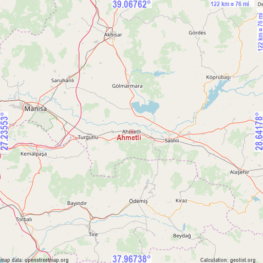
Ahmetli GPS coordinates[2]
38° 31' 10.56" North, 27° 56' 19.14" East
| Map corner | latitude | longitude |
|---|---|---|
| Upper-left | 39.06762°, | 27.23553° |
| Center: | 38.5196°, | 27.93865° |
| Lower-right: | 37.96738°, | 28.64178° |
| Map W x H: | 122.3×122.3 km | = 76×76mi |
| max Lat: | 42.02683° ⇑52.6% North |
| Ahmetli: | 38.5196° |
| min Lat: | ⇓47.4% South 35.9025° |
| min Long | Ahmetli | max Long |
| 25.90902° | 27.93865° | 44.60099° |
| W 9.2%⇐ | ⇒90.8% E |
Elevation
Elevation of Ahmetli is 85 m = 279 ft, and this is 632.4 m = 2075 ft below average elevation for this country.
| Max E: |
2682 m = 8799 ft | 83.1% |
| Avg. | 717.4 m = 2354 ft | |
| Ahmetli | 85 m = 279 ft | |
Min E: |
0 m = 0 ft | 16.9% |
See also: Turkey elevation on elevation.city.
Geographical zone
Ahmetli is located in North temperate zone (between Tropic of Cancer and the Arctic Circle). Distance of this Northern Tropic circle is 1677.1 km =1042.1 mi to South.| Distance of | km | miles | from Ahmetli |
|---|---|---|---|
| North Pole | 5724.1 | 3556.8 | to North |
| Arctic Circle | 3118.2 | 1937.6 | to North |
| Tropic Cancer | 1677.1 | 1042.1 | to South |
| Equator | 4283 | 2661.3 | to South |


Nearby cities:
15 places around Ahmetli: (largest is in red/bold)
• Adala
29.4 km =18.3 mi,  77°
77°
• Akhisar
45.2 km =28.1 mi,  349°
349°
• Bayındır
42.1 km =26.2 mi,  217°
217°
• Birgi
31.7 km =19.7 mi,  160°
160°
• Gölmarmara
21.7 km =13.5 mi, 354°
• Halitpaşa
29.2 km =18.1 mi,  309°
309°
• Karaoğlanlı
32.4 km =20.1 mi,  271°
271°
• Kaymakçı
42 km =26.1 mi, 158°
• Kiraz
39.6 km =24.6 mi,  144°
144°
• Konaklı
45.5 km =28.3 mi,  173°
173°
• Salihli
18.7 km =11.6 mi,  102°
102°
• Saruhanlı
40.1 km =24.9 mi, 306°
• Turgutlu
21 km =13 mi,  262°
262°
• Çaylı
44.5 km =27.7 mi, 156°
• Ödemiş
32.6 km =20.3 mi,  175°
175°
Sources, notices
• [Note1] Compared only with cities in Turkey existing in our database
• [Src1] Map data: © OpenStreetMap contributors (CC-BY-SA)
• [Src2] Other city data from geonames.org with taken over terms of usage.
• [Src3] Geographical zone / Annual Mean Temperature by Robert A. Rohde @ Wikipedia
