Turgutlu geodata
Turgutlu (Manisa) is a seat of a second-order administrative division; located in Turkey in Europe/Istanbul (GMT+3) time zone. With population of 103,292 people, there are 80 cities with bigger population in this country. Compared to other cities in Turkey, 52.9% of cities are located further ↑North; 92.2% of cities are located further →East and 81.8% of cities have higher elevation than Turgutlu. Note1


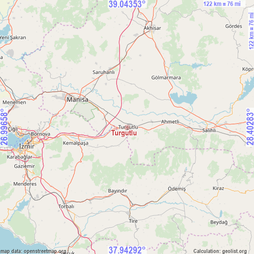
Turgutlu GPS coordinates[2]
38° 29' 43.188" North, 27° 41' 58.92" East
| Map corner | latitude | longitude |
|---|---|---|
| Upper-left | 39.04353°, | 26.99658° |
| Center: | 38.49533°, | 27.6997° |
| Lower-right: | 37.94292°, | 28.40283° |
| Map W x H: | 122.4×122.4 km | = 76.1×76.1mi |
| max Lat: | 42.02683° ⇑52.9% North |
| Turgutlu: | 38.49533° |
| min Lat: | ⇓47.1% South 35.9025° |
| min Long | Turgutlu | max Long |
| 25.90902° | 27.6997° | 44.60099° |
| W 7.8%⇐ | ⇒92.2% E |
Elevation
Elevation of Turgutlu is 98 m = 322 ft, and this is 619.4 m = 2032 ft below average elevation for this country.
| Max E: |
2682 m = 8799 ft | 81.8% |
| Avg. | 717.4 m = 2354 ft | |
| Turgutlu | 98 m = 322 ft | |
Min E: |
0 m = 0 ft | 18.2% |
See also: Turgutlu elevation on elevation.city.
Geographical zone
Turgutlu is located in North temperate zone (between Tropic of Cancer and the Arctic Circle). Distance of this Northern Tropic circle is 1674.4 km =1040.4 mi to South.| Distance of | km | miles | from Turgutlu |
|---|---|---|---|
| North Pole | 5726.8 | 3558.5 | to North |
| Arctic Circle | 3120.9 | 1939.2 | to North |
| Tropic Cancer | 1674.4 | 1040.4 | to South |
| Equator | 4280.3 | 2659.7 | to South |


Nearby cities:
15 places around Turgutlu: (largest is in red/bold)
• Ahmetli
21 km =13 mi,  82°
82°
• Bayındır
31.2 km =19.4 mi,  188°
188°
• Bornova
40.1 km =24.9 mi,  267°
267°
• Dağkızılca
33.8 km =21 mi,  232°
232°
• Gölmarmara
30.6 km =19 mi,  37°
37°
• Halitpaşa
21.2 km =13.2 mi,  354°
354°
• Karaoğlanlı
12.2 km =7.6 mi,  288°
288°
• Kemalpaşa
25.8 km =16 mi,  252°
252°
• Manisa
27.1 km =16.8 mi,  298°
298°
• Muradiye
36.4 km =22.6 mi, 300°
• Salihli
39 km =24.2 mi,  92°
92°
• Saruhanlı
29 km =18 mi,  336°
336°
• Çırpı
40.8 km =25.4 mi,  205°
205°
• Ödemiş
37.9 km =23.5 mi,  141°
141°
• Üçpınar
39.6 km =24.6 mi,  312°
312°
Sources, notices
• [Note1] Compared only with cities in Turkey existing in our database
• [Src1] Map data: © OpenStreetMap contributors (CC-BY-SA)
• [Src2] Other city data from geonames.org with taken over terms of usage.
• [Src3] Geographical zone / Annual Mean Temperature by Robert A. Rohde @ Wikipedia
