Yalvaç geodata
Yalvaç (Isparta) is a seat of a second-order administrative division; located in Turkey in Europe/Istanbul (GMT+3) time zone. With population of 39,145 people, there are 208 cities with bigger population in this country. Compared to other cities in Turkey, 56.3% of cities are located further ↑North; 69.8% of cities are located further →East and 74.7% of cities have lower elevation than Yalvaç. Note1


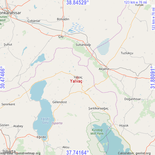
Yalvaç GPS coordinates[2]
38° 17' 44.016" North, 31° 10' 40.008" East
| Map corner | latitude | longitude |
|---|---|---|
| Upper-left | 38.84529°, | 30.47466° |
| Center: | 38.29556°, | 31.17778° |
| Lower-right: | 37.74164°, | 31.88091° |
| Map W x H: | 122.7×122.7 km | = 76.2×76.2mi |
| max Lat: | 42.02683° ⇑56.3% North |
| Yalvaç: | 38.29556° |
| min Lat: | ⇓43.7% South 35.9025° |
| min Long | Yalvaç | max Long |
| 25.90902° | 31.17778° | 44.60099° |
| W 30.2%⇐ | ⇒69.8% E |
Elevation
Elevation of Yalvaç is 1100 m = 3609 ft, and this is 382.6 m = 1255 ft above average elevation for this country.
| Max E: |
2682 m = 8799 ft | 25.3% |
| Yalvaç | 1100 m 3609 ft | |
| Avg. | 717.4 m = 2354 ft | |
Min E: |
0 m = 0 ft | 74.7% |
See also: Turkey elevation on elevation.city.
Geographical zone
Yalvaç is located in North temperate zone (between Tropic of Cancer and the Arctic Circle). Distance of this Northern Tropic circle is 1652.1 km =1026.6 mi to South.| Distance of | km | miles | from Yalvaç |
|---|---|---|---|
| North Pole | 5749 | 3572.3 | to North |
| Arctic Circle | 3143.1 | 1953 | to North |
| Tropic Cancer | 1652.1 | 1026.6 | to South |
| Equator | 4258.1 | 2645.9 | to South |


Nearby cities:
15 places around Yalvaç: (largest is in red/bold)
• Akşehir
21.9 km =13.6 mi,  71°
71°
• Argıthanı
46.8 km =29.1 mi,  90°
90°
• Barla
46.3 km =28.8 mi,  228°
228°
• Bağkonak
12 km =7.5 mi,  136°
136°
• Bolvadin
47.6 km =29.6 mi,  346°
346°
• Doğanhisar
46.6 km =29 mi,  110°
110°
• Eğirdir
54.9 km =34.1 mi,  211°
211°
• Gelendost
24.1 km =15 mi,  216°
216°
• Hüyük
52.8 km =32.8 mi, 136°
• Kumdanlı
17.9 km =11.1 mi,  280°
280°
• Reis
34.5 km =21.4 mi, 94°
• Sultandağı
26.6 km =16.5 mi,  9°
9°
• Tuzlukçu
44 km =27.3 mi,  62°
62°
• Çay
35.4 km =22 mi,  338°
338°
• Şarkîkaraağaç
29.1 km =18.1 mi,  145°
145°
Sources, notices
• [Note1] Compared only with cities in Turkey existing in our database
• [Src1] Map data: © OpenStreetMap contributors (CC-BY-SA)
• [Src2] Other city data from geonames.org with taken over terms of usage.
• [Src3] Geographical zone / Annual Mean Temperature by Robert A. Rohde @ Wikipedia
