Hıdırbaba geodata
Hıdırbaba (Elazığ) is a seat of a third-order administrative division; located in Turkey in Europe/Istanbul (GMT+3) time zone. In our database, there are 1323 cities with bigger population. Compared to other cities in Turkey, 51.4% of cities are located further ↓South; 67.3% of cities are located further ←West and 76.1% of cities have lower elevation than Hıdırbaba. Note1


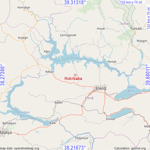
Hıdırbaba GPS coordinates[2]
38° 46' 1.416" North, 38° 58' 37.128" East
| Map corner | latitude | longitude |
|---|---|---|
| Upper-left | 39.31318°, | 38.27386° |
| Center: | 38.76706°, | 38.97698° |
| Lower-right: | 38.21673°, | 39.68011° |
| Map W x H: | 121.9×121.9 km | = 75.7×75.7mi |
| max Lat: | 42.02683° ⇑48.6% North |
| Hıdırbaba: | 38.76706° |
| min Lat: | ⇓51.4% South 35.9025° |
| min Long | Hıdırbaba | max Long |
| 25.90902° | 38.97698° | 44.60099° |
| W 67.3%⇐ | ⇒32.7% E |
Elevation
Elevation of Hıdırbaba is 1124 m = 3688 ft, and this is 406.6 m = 1334 ft above average elevation for this country.
| Max E: |
2682 m = 8799 ft | 23.9% |
| Hıdırbaba | 1124 m 3688 ft | |
| Avg. | 717.4 m = 2354 ft | |
Min E: |
0 m = 0 ft | 76.1% |
See also: Turkey elevation on elevation.city.
Geographical zone
Hıdırbaba is located in North temperate zone (between Tropic of Cancer and the Arctic Circle). Distance of this Northern Tropic circle is 1704.6 km =1059.2 mi to South.| Distance of | km | miles | from Hıdırbaba |
|---|---|---|---|
| North Pole | 5696.6 | 3539.7 | to North |
| Arctic Circle | 3090.7 | 1920.5 | to North |
| Tropic Cancer | 1704.6 | 1059.2 | to South |
| Equator | 4310.5 | 2678.4 | to South |


Nearby cities:
15 places around Hıdırbaba: (largest is in red/bold)
• Akçapınar
20.3 km =12.6 mi,  351°
351°
• Ağın
29.8 km =18.5 mi,  309°
309°
• Baskil
26.1 km =16.2 mi,  212°
212°
• Dere
36.9 km =22.9 mi,  49°
49°
• Elazığ
23.7 km =14.7 mi,  115°
115°
• Gedikler
38.1 km =23.7 mi,  336°
336°
• Gözeli
38.7 km =24 mi,  169°
169°
• Hankendi
23.1 km =14.4 mi,  162°
162°
• Harput
24 km =14.9 mi,  107°
107°
• Keban
21.2 km =13.2 mi,  278°
278°
• Mollakendi
37.4 km =23.2 mi, 124°
• Pertek
31.9 km =19.8 mi,  69°
69°
• Poyraz
9.9 km =6.2 mi, 156°
• Çağlarca
33.1 km =20.6 mi,  24°
24°
• Çemişgezek
32.6 km =20.3 mi, 349°
Sources, notices
• [Note1] Compared only with cities in Turkey existing in our database
• [Src1] Map data: © OpenStreetMap contributors (CC-BY-SA)
• [Src2] Other city data from geonames.org with taken over terms of usage.
• [Src3] Geographical zone / Annual Mean Temperature by Robert A. Rohde @ Wikipedia
