Pamukkale geodata
Pamukkale (Denizli) is a populated place; located in Turkey in Europe/Istanbul (GMT+3) time zone. With population of 10,000 people, there are 510 cities with bigger population in this country. Compared to other cities in Turkey, 64.1% of cities are located further ↑North; 82.8% of cities are located further →East and 71.3% of cities have higher elevation than Pamukkale. Note1


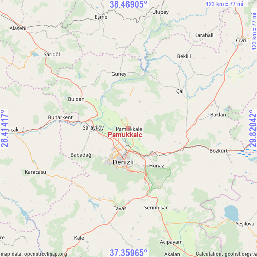
Pamukkale GPS coordinates[2]
37° 54' 59.184" North, 29° 7' 2.244" East
| Map corner | latitude | longitude |
|---|---|---|
| Upper-left | 38.46905°, | 28.41417° |
| Center: | 37.91644°, | 29.11729° |
| Lower-right: | 37.35965°, | 29.82042° |
| Map W x H: | 123.4×123.4 km | = 76.7×76.7mi |
| max Lat: | 42.02683° ⇑64.1% North |
| Pamukkale: | 37.91644° |
| min Lat: | ⇓35.9% South 35.9025° |
| min Long | Pamukkale | max Long |
| 25.90902° | 29.11729° | 44.60099° |
| W 17.2%⇐ | ⇒82.8% E |
Elevation
Elevation of Pamukkale is 255 m = 837 ft, and this is 462.4 m = 1517 ft below average elevation for this country.
| Max E: |
2682 m = 8799 ft | 71.3% |
| Avg. | 717.4 m = 2354 ft | |
| Pamukkale | 255 m = 837 ft | |
Min E: |
0 m = 0 ft | 28.7% |
See also: Turkey elevation on elevation.city.
Geographical zone
Pamukkale is located in North temperate zone (between Tropic of Cancer and the Arctic Circle). Distance of this Northern Tropic circle is 1610 km =1000.4 mi to South.| Distance of | km | miles | from Pamukkale |
|---|---|---|---|
| North Pole | 5791.1 | 3598.4 | to North |
| Arctic Circle | 3185.3 | 1979.3 | to North |
| Tropic Cancer | 1610 | 1000.4 | to South |
| Equator | 4215.9 | 2619.6 | to South |


Nearby cities:
15 places around Pamukkale: (largest is in red/bold)
• Akkent
34.9 km =21.7 mi,  41°
41°
• Akköy
5.7 km =3.5 mi,  322°
322°
• Babadağ
25.9 km =16.1 mi,  242°
242°
• Buharkent
33.3 km =20.7 mi,  279°
279°
• Buldan
28.9 km =18 mi,  299°
299°
• Denizli
16 km =9.9 mi,  189°
189°
• Gözler
21.4 km =13.3 mi,  8°
8°
• Güney
26.8 km =16.7 mi,  350°
350°
• Honaz
22.2 km =13.8 mi,  142°
142°
• Kızılcabölük
35 km =21.7 mi, 194°
• Merkezefendi
14 km =8.7 mi,  208°
208°
• Pamukkale
14 km =8.7 mi, 185°
• Sarayköy
16.9 km =10.5 mi,  273°
273°
• Tavas
38.4 km =23.9 mi, 186°
• Çal
30.9 km =19.2 mi,  53°
53°
In other languages:
- In Spanish: Hierápolis
- In German: Hierapolis
- In Russian: Памуккале
- In Chinese: 棉花堡
Sources, notices
• [Note1] Compared only with cities in Turkey existing in our database
• [Src1] Map data: © OpenStreetMap contributors (CC-BY-SA)
• [Src2] Other city data from geonames.org with taken over terms of usage.
• [Src3] Geographical zone / Annual Mean Temperature by Robert A. Rohde @ Wikipedia
