Sarayköy geodata
Sarayköy (Denizli) is a seat of a second-order administrative division; located in Turkey in Europe/Istanbul (GMT+3) time zone. With population of 18,937 people, there are 345 cities with bigger population in this country. Compared to other cities in Turkey, 63.7% of cities are located further ↑North; 84.4% of cities are located further →East and 76% of cities have higher elevation than Sarayköy. Note1


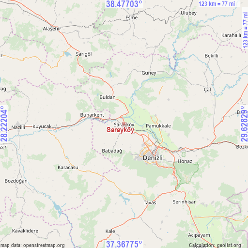
Sarayköy GPS coordinates[2]
37° 55' 28.128" North, 28° 55' 30.576" East
| Map corner | latitude | longitude |
|---|---|---|
| Upper-left | 38.47703°, | 28.22204° |
| Center: | 37.92448°, | 28.92516° |
| Lower-right: | 37.36775°, | 29.62829° |
| Map W x H: | 123.3×123.3 km | = 76.6×76.6mi |
| max Lat: | 42.02683° ⇑63.7% North |
| Sarayköy: | 37.92448° |
| min Lat: | ⇓36.3% South 35.9025° |
| min Long | Sarayköy | max Long |
| 25.90902° | 28.92516° | 44.60099° |
| W 15.6%⇐ | ⇒84.4% E |
Elevation
Elevation of Sarayköy is 163 m = 535 ft, and this is 554.4 m = 1819 ft below average elevation for this country.
| Max E: |
2682 m = 8799 ft | 76% |
| Avg. | 717.4 m = 2354 ft | |
| Sarayköy | 163 m = 535 ft | |
Min E: |
0 m = 0 ft | 24% |
See also: Turkey elevation on elevation.city.
Geographical zone
Sarayköy is located in North temperate zone (between Tropic of Cancer and the Arctic Circle). Distance of this Northern Tropic circle is 1610.9 km =1001 mi to South.| Distance of | km | miles | from Sarayköy |
|---|---|---|---|
| North Pole | 5790.3 | 3597.9 | to North |
| Arctic Circle | 3184.4 | 1978.7 | to North |
| Tropic Cancer | 1610.9 | 1001 | to South |
| Equator | 4216.8 | 2620.2 | to South |


Nearby cities:
15 places around Sarayköy: (largest is in red/bold)
• Akköy
13.9 km =8.6 mi,  74°
74°
• Babadağ
14.3 km =8.9 mi,  204°
204°
• Buharkent
16.6 km =10.3 mi,  285°
285°
• Buldan
15.8 km =9.8 mi,  328°
328°
• Denizli
22 km =13.7 mi,  139°
139°
• Gözler
28.5 km =17.7 mi,  44°
44°
• Güney
28.5 km =17.7 mi,  26°
26°
• Honaz
35.5 km =22.1 mi,  121°
121°
• Horsunlu
29.3 km =18.2 mi,  267°
267°
• Karacasu
35.5 km =22.1 mi,  232°
232°
• Merkezefendi
16.8 km =10.4 mi, 142°
• Pamukkale
16.9 km =10.5 mi,  93°
93°
• Pamukkale
21.4 km =13.3 mi,  133°
133°
• Pamukören
33.6 km =20.9 mi, 269°
• Yenice
32.9 km =20.4 mi,  251°
251°
Sources, notices
• [Note1] Compared only with cities in Turkey existing in our database
• [Src1] Map data: © OpenStreetMap contributors (CC-BY-SA)
• [Src2] Other city data from geonames.org with taken over terms of usage.
• [Src3] Geographical zone / Annual Mean Temperature by Robert A. Rohde @ Wikipedia
