Merkezefendi geodata
Merkezefendi (Denizli) is a seat of a second-order administrative division; located in Turkey in Europe/Istanbul (GMT+3) time zone. With population of 280,341 people, there are 38 cities with bigger population in this country. Compared to other cities in Turkey, 68.4% of cities are located further ↑North; 83.7% of cities are located further →East and 63.8% of cities have higher elevation than Merkezefendi. Note1


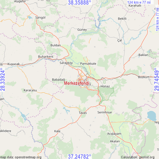
Merkezefendi GPS coordinates[2]
37° 48' 19.584" North, 29° 2' 32.496" East
| Map corner | latitude | longitude |
|---|---|---|
| Upper-left | 38.35888°, | 28.33924° |
| Center: | 37.80544°, | 29.04236° |
| Lower-right: | 37.24782°, | 29.74549° |
| Map W x H: | 123.5×123.5 km | = 76.7×76.7mi |
| max Lat: | 42.02683° ⇑68.4% North |
| Merkezefendi: | 37.80544° |
| min Lat: | ⇓31.6% South 35.9025° |
| min Long | Merkezefendi | max Long |
| 25.90902° | 29.04236° | 44.60099° |
| W 16.3%⇐ | ⇒83.7% E |
Elevation
Elevation of Merkezefendi is 439 m = 1440 ft, and this is 278.4 m = 913 ft below average elevation for this country.
| Max E: |
2682 m = 8799 ft | 63.8% |
| Avg. | 717.4 m = 2354 ft | |
| Merkezefendi | 439 m = 1440 ft | |
Min E: |
0 m = 0 ft | 36.2% |
See also: Merkezefendi elevation on elevation.city.
Geographical zone
Merkezefendi is located in North temperate zone (between Tropic of Cancer and the Arctic Circle). Distance of this Northern Tropic circle is 1597.7 km =992.8 mi to South.| Distance of | km | miles | from Merkezefendi |
|---|---|---|---|
| North Pole | 5803.5 | 3606.1 | to North |
| Arctic Circle | 3197.6 | 1986.9 | to North |
| Tropic Cancer | 1597.7 | 992.8 | to South |
| Equator | 4203.6 | 2612 | to South |


Nearby cities:
15 places around Merkezefendi: (largest is in red/bold)
• Akköy
17.1 km =10.6 mi,  10°
10°
• Babadağ
16.3 km =10.1 mi,  270°
270°
• Buharkent
31.7 km =19.7 mi,  303°
303°
• Buldan
32.5 km =20.2 mi,  325°
325°
• Denizli
5.3 km =3.3 mi,  131°
131°
• Gözler
34.9 km =21.7 mi,  16°
16°
• Güney
38.9 km =24.2 mi,  3°
3°
• Honaz
20.7 km =12.9 mi,  104°
104°
• Karacasu
39.3 km =24.4 mi,  257°
257°
• Kızılcabölük
21.6 km =13.4 mi,  185°
185°
• Pamukkale
5.4 km =3.4 mi,  106°
106°
• Pamukkale
14 km =8.7 mi,  28°
28°
• Sarayköy
16.8 km =10.4 mi,  322°
322°
• Serinhisar
31.8 km =19.8 mi,  141°
141°
• Tavas
25.9 km =16.1 mi,  174°
174°
Sources, notices
• [Note1] Compared only with cities in Turkey existing in our database
• [Src1] Map data: © OpenStreetMap contributors (CC-BY-SA)
• [Src2] Other city data from geonames.org with taken over terms of usage.
• [Src3] Geographical zone / Annual Mean Temperature by Robert A. Rohde @ Wikipedia
