Buldan geodata
Buldan (Denizli) is a seat of a second-order administrative division; located in Turkey in Europe/Istanbul (GMT+3) time zone. With population of 14,811 people, there are 393 cities with bigger population in this country. Compared to other cities in Turkey, 60.6% of cities are located further ↑North; 85.3% of cities are located further →East and 53% of cities have higher elevation than Buldan. Note1


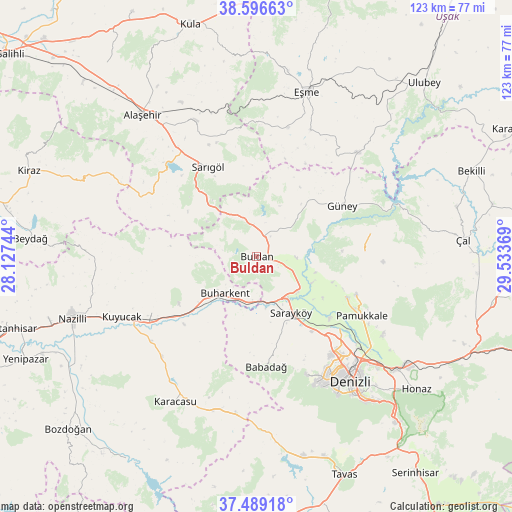
Buldan GPS coordinates[2]
38° 2' 42" North, 28° 49' 50.016" East
| Map corner | latitude | longitude |
|---|---|---|
| Upper-left | 38.59663°, | 28.12744° |
| Center: | 38.045°, | 28.83056° |
| Lower-right: | 37.48918°, | 29.53369° |
| Map W x H: | 123.1×123.1 km | = 76.5×76.5mi |
| max Lat: | 42.02683° ⇑60.6% North |
| Buldan: | 38.045° |
| min Lat: | ⇓39.4% South 35.9025° |
| min Long | Buldan | max Long |
| 25.90902° | 28.83056° | 44.60099° |
| W 14.7%⇐ | ⇒85.3% E |
Elevation
Elevation of Buldan is 633 m = 2077 ft, and this is 84.4 m = 277 ft below average elevation for this country.
| Max E: |
2682 m = 8799 ft | 53% |
| Avg. | 717.4 m = 2354 ft | |
| Buldan | 633 m = 2077 ft | |
Min E: |
0 m = 0 ft | 47% |
See also: Turkey elevation on elevation.city.
Geographical zone
Buldan is located in North temperate zone (between Tropic of Cancer and the Arctic Circle). Distance of this Northern Tropic circle is 1624.3 km =1009.3 mi to South.| Distance of | km | miles | from Buldan |
|---|---|---|---|
| North Pole | 5776.9 | 3589.6 | to North |
| Arctic Circle | 3171 | 1970.4 | to North |
| Tropic Cancer | 1624.3 | 1009.3 | to South |
| Equator | 4230.2 | 2628.5 | to South |


Nearby cities:
15 places around Buldan: (largest is in red/bold)
• Akköy
23.8 km =14.8 mi,  114°
114°
• Babadağ
26.5 km =16.5 mi,  175°
175°
• Buharkent
11.9 km =7.4 mi,  220°
220°
• Gözler
29.1 km =18.1 mi,  76°
76°
• Güllü
34.7 km =21.6 mi,  43°
43°
• Güney
24.1 km =15 mi,  59°
59°
• Horsunlu
25.5 km =15.8 mi,  235°
235°
• Kuyucak
35.7 km =22.2 mi,  245°
245°
• Merkezefendi
32.5 km =20.2 mi,  145°
145°
• Pamukkale
28.9 km =18 mi,  119°
119°
• Pamukören
28.7 km =17.8 mi, 241°
• Sarayköy
15.8 km =9.8 mi, 148°
• Sarıgöl
24.6 km =15.3 mi,  331°
331°
• Yenice
33.1 km =20.6 mi, 223°
• Yeşilyurt
35.8 km =22.2 mi,  336°
336°
Sources, notices
• [Note1] Compared only with cities in Turkey existing in our database
• [Src1] Map data: © OpenStreetMap contributors (CC-BY-SA)
• [Src2] Other city data from geonames.org with taken over terms of usage.
• [Src3] Geographical zone / Annual Mean Temperature by Robert A. Rohde @ Wikipedia
