Buharkent geodata
Buharkent (Aydın) is a seat of a second-order administrative division; located in Turkey in Europe/Istanbul (GMT+3) time zone. With population of 7,723 people, there are 586 cities with bigger population in this country. Compared to other cities in Turkey, 62.3% of cities are located further ↑North; 85.7% of cities are located further →East and 75.1% of cities have higher elevation than Buharkent. Note1


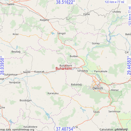
Buharkent GPS coordinates[2]
37° 57' 50.292" North, 28° 44' 33.72" East
| Map corner | latitude | longitude |
|---|---|---|
| Upper-left | 38.51622°, | 28.03958° |
| Center: | 37.96397°, | 28.7427° |
| Lower-right: | 37.40754°, | 29.44583° |
| Map W x H: | 123.3×123.3 km | = 76.6×76.6mi |
| max Lat: | 42.02683° ⇑62.3% North |
| Buharkent: | 37.96397° |
| min Lat: | ⇓37.7% South 35.9025° |
| min Long | Buharkent | max Long |
| 25.90902° | 28.7427° | 44.60099° |
| W 14.3%⇐ | ⇒85.7% E |
Elevation
Elevation of Buharkent is 174 m = 571 ft, and this is 543.4 m = 1783 ft below average elevation for this country.
| Max E: |
2682 m = 8799 ft | 75.1% |
| Avg. | 717.4 m = 2354 ft | |
| Buharkent | 174 m = 571 ft | |
Min E: |
0 m = 0 ft | 24.9% |
See also: Turkey elevation on elevation.city.
Geographical zone
Buharkent is located in North temperate zone (between Tropic of Cancer and the Arctic Circle). Distance of this Northern Tropic circle is 1615.3 km =1003.7 mi to South.| Distance of | km | miles | from Buharkent |
|---|---|---|---|
| North Pole | 5785.9 | 3595.2 | to North |
| Arctic Circle | 3180 | 1976 | to North |
| Tropic Cancer | 1615.3 | 1003.7 | to South |
| Equator | 4221.2 | 2622.9 | to South |


Nearby cities:
15 places around Buharkent: (largest is in red/bold)
• Akköy
29.4 km =18.3 mi,  91°
91°
• Babadağ
20.1 km =12.5 mi,  150°
150°
• Buldan
11.9 km =7.4 mi,  40°
40°
• Denizli
36.9 km =22.9 mi,  124°
124°
• Güney
35.5 km =22.1 mi,  53°
53°
• Horsunlu
14.4 km =8.9 mi,  247°
247°
• Karacasu
28.8 km =17.9 mi,  204°
204°
• Kuyucak
25.5 km =15.8 mi,  257°
257°
• Merkezefendi
31.7 km =19.7 mi, 123°
• Pamukkale
33.3 km =20.7 mi,  99°
99°
• Pamukkale
36.9 km =22.9 mi, 121°
• Pamukören
18.2 km =11.3 mi, 255°
• Sarayköy
16.6 km =10.3 mi,  105°
105°
• Sarıgöl
30.9 km =19.2 mi,  352°
352°
• Yenice
21.3 km =13.2 mi,  224°
224°
Sources, notices
• [Note1] Compared only with cities in Turkey existing in our database
• [Src1] Map data: © OpenStreetMap contributors (CC-BY-SA)
• [Src2] Other city data from geonames.org with taken over terms of usage.
• [Src3] Geographical zone / Annual Mean Temperature by Robert A. Rohde @ Wikipedia
