Tavas geodata
Tavas (Denizli) is a seat of a second-order administrative division; located in Turkey in Europe/Istanbul (GMT+3) time zone. With population of 11,584 people, there are 464 cities with bigger population in this country. Compared to other cities in Turkey, 73% of cities are located further ↑North; 83.4% of cities are located further →East and 64.2% of cities have lower elevation than Tavas. Note1


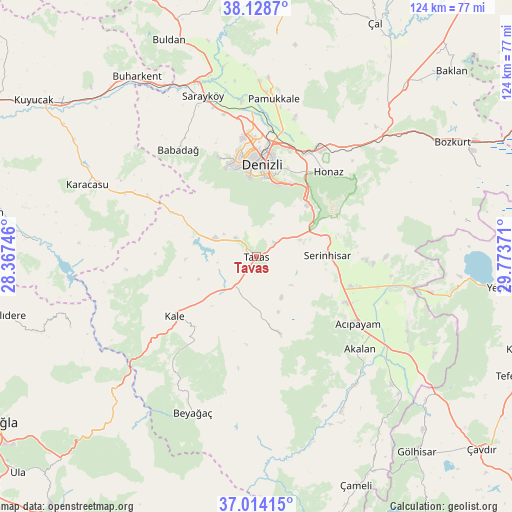
Tavas GPS coordinates[2]
37° 34' 24.636" North, 29° 4' 14.088" East
| Map corner | latitude | longitude |
|---|---|---|
| Upper-left | 38.1287°, | 28.36746° |
| Center: | 37.57351°, | 29.07058° |
| Lower-right: | 37.01415°, | 29.77371° |
| Map W x H: | 123.9×123.9 km | = 77×77mi |
| max Lat: | 42.02683° ⇑73% North |
| Tavas: | 37.57351° |
| min Lat: | ⇓27% South 35.9025° |
| min Long | Tavas | max Long |
| 25.90902° | 29.07058° | 44.60099° |
| W 16.6%⇐ | ⇒83.4% E |
Elevation
Elevation of Tavas is 948 m = 3110 ft, and this is 230.6 m = 757 ft above average elevation for this country.
| Max E: |
2682 m = 8799 ft | 35.8% |
| Tavas | 948 m 3110 ft | |
| Avg. | 717.4 m = 2354 ft | |
Min E: |
0 m = 0 ft | 64.2% |
See also: Turkey elevation on elevation.city.
Geographical zone
Tavas is located in North temperate zone (between Tropic of Cancer and the Arctic Circle). Distance of this Northern Tropic circle is 1571.9 km =976.7 mi to South.| Distance of | km | miles | from Tavas |
|---|---|---|---|
| North Pole | 5829.3 | 3622.2 | to North |
| Arctic Circle | 3223.4 | 2002.9 | to North |
| Tropic Cancer | 1571.9 | 976.7 | to South |
| Equator | 4177.8 | 2596 | to South |


Nearby cities:
15 places around Tavas: (largest is in red/bold)
• Acıpayam
29.7 km =18.5 mi,  124°
124°
• Akköy
42.6 km =26.5 mi,  0°
0°
• Babadağ
32.1 km =19.9 mi,  324°
324°
• Beyağaç
40.6 km =25.2 mi,  202°
202°
• Denizli
22.4 km =13.9 mi, 3°
• Honaz
26.9 km =16.7 mi,  40°
40°
• Kale
24.9 km =15.5 mi,  233°
233°
• Kelekçi
42.4 km =26.3 mi,  150°
150°
• Kızılcabölük
6.3 km =3.9 mi,  312°
312°
• Merkezefendi
25.9 km =16.1 mi,  354°
354°
• Nikfer
19.6 km =12.2 mi,  162°
162°
• Pamukkale
24.4 km =15.2 mi,  6°
6°
• Pamukkale
38.4 km =23.9 mi, 6°
• Sarayköy
41.1 km =25.5 mi,  341°
341°
• Serinhisar
17.3 km =10.7 mi,  87°
87°
Sources, notices
• [Note1] Compared only with cities in Turkey existing in our database
• [Src1] Map data: © OpenStreetMap contributors (CC-BY-SA)
• [Src2] Other city data from geonames.org with taken over terms of usage.
• [Src3] Geographical zone / Annual Mean Temperature by Robert A. Rohde @ Wikipedia
