Ortyakent Yahşi geodata
Ortyakent Yahşi (Muğla) is a seat of a third-order administrative division; located in Turkey in Europe/Istanbul (GMT+3) time zone. In our database, there are 1323 cities with bigger population. Compared to other cities in Turkey, 87% of cities are located further ↑North; 94.6% of cities are located further →East and 91.3% of cities have higher elevation than Ortyakent Yahşi. Note1


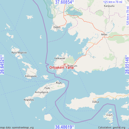
Ortyakent Yahşi GPS coordinates[2]
37° 2' 57.984" North, 27° 20' 53.988" East
| Map corner | latitude | longitude |
|---|---|---|
| Upper-left | 37.60854°, | 26.64521° |
| Center: | 37.04944°, | 27.34833° |
| Lower-right: | 36.48619°, | 28.05146° |
| Map W x H: | 124.8×124.8 km | = 77.5×77.5mi |
| max Lat: | 42.02683° ⇑87% North |
| Ortyakent Yahşi: | 37.04944° |
| min Lat: | ⇓13% South 35.9025° |
| min Long | Ortyakent Yahş | max Long |
| 25.90902° | 27.34833° | 44.60099° |
| W 5.4%⇐ | ⇒94.6% E |
Elevation
Elevation of Ortyakent Yahşi is 32 m = 105 ft, and this is 685.4 m = 2249 ft below average elevation for this country.
| Max E: |
2682 m = 8799 ft | 91.3% |
| Avg. | 717.4 m = 2354 ft | |
| Ortyakent Yahşi | 32 m = 105 ft | |
Min E: |
0 m = 0 ft | 8.7% |
See also: Turkey elevation on elevation.city.
Geographical zone
Ortyakent Yahşi is located in North temperate zone (between Tropic of Cancer and the Arctic Circle). Distance of this Northern Tropic circle is 1513.6 km =940.5 mi to South.| Distance of | km | miles | from Ortyakent Yahşi |
|---|---|---|---|
| North Pole | 5887.6 | 3658.4 | to North |
| Arctic Circle | 3281.7 | 2039.2 | to North |
| Tropic Cancer | 1513.6 | 940.5 | to South |
| Equator | 4119.5 | 2559.7 | to South |


Nearby cities:
15 places around Ortyakent Yahşi: (largest is in red/bold)
• Akköy
49.6 km =30.8 mi,  351°
351°
• Atburgazı
65.9 km =40.9 mi, 352°
• Bodrum
7.3 km =4.5 mi,  99°
99°
• Datça
45.7 km =28.4 mi,  139°
139°
• Didim
38.2 km =23.7 mi, 347°
• Güvercinlik
22.9 km =14.2 mi,  64°
64°
• Karaova
28.9 km =18 mi,  77°
77°
• Karatoprak
8.9 km =5.5 mi,  243°
243°
• Kiulukioi
30.8 km =19.1 mi,  46°
46°
• Milas
48.7 km =30.3 mi, 52°
• Sarıkemer
57.5 km =35.7 mi,  1°
1°
• Selimiye
47.6 km =29.6 mi,  34°
34°
• Turgutreis
8.1 km =5 mi, 243°
• Yalıkavak
7.7 km =4.8 mi,  323°
323°
• Ören
54.9 km =34.1 mi,  91°
91°
Sources, notices
• [Note1] Compared only with cities in Turkey existing in our database
• [Src1] Map data: © OpenStreetMap contributors (CC-BY-SA)
• [Src2] Other city data from geonames.org with taken over terms of usage.
• [Src3] Geographical zone / Annual Mean Temperature by Robert A. Rohde @ Wikipedia
