Datça geodata
Datça (Muğla) is a populated place; located in Turkey in Europe/Istanbul (GMT+3) time zone. With population of 10,121 people, there are 505 cities with bigger population in this country. Compared to other cities in Turkey, 94.3% of cities are located further ↑North; 92.3% of cities are located further →East and 91.5% of cities have higher elevation than Datça. Note1


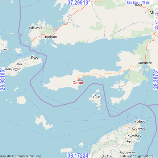
Datça GPS coordinates[2]
36° 44' 16.008" North, 27° 41' 3.012" East
| Map corner | latitude | longitude |
|---|---|---|
| Upper-left | 37.29918°, | 26.98105° |
| Center: | 36.73778°, | 27.68417° |
| Lower-right: | 36.17224°, | 28.3873° |
| Map W x H: | 125.3×125.3 km | = 77.9×77.9mi |
| max Lat: | 42.02683° ⇑94.3% North |
| Datça: | 36.73778° |
| min Lat: | ⇓5.7% South 35.9025° |
| min Long | Datça | max Long |
| 25.90902° | 27.68417° | 44.60099° |
| W 7.7%⇐ | ⇒92.3% E |
Elevation
Elevation of Datça is 31 m = 102 ft, and this is 686.4 m = 2252 ft below average elevation for this country.
| Max E: |
2682 m = 8799 ft | 91.5% |
| Avg. | 717.4 m = 2354 ft | |
| Datça | 31 m = 102 ft | |
Min E: |
0 m = 0 ft | 8.5% |
See also: Turkey elevation on elevation.city.
Geographical zone
Datça is located in North temperate zone (between Tropic of Cancer and the Arctic Circle). Distance of this Northern Tropic circle is 1478.9 km =918.9 mi to South.| Distance of | km | miles | from Datça |
|---|---|---|---|
| North Pole | 5922.2 | 3679.9 | to North |
| Arctic Circle | 3316.3 | 2060.7 | to North |
| Tropic Cancer | 1478.9 | 918.9 | to South |
| Equator | 4084.9 | 2538.2 | to South |


Nearby cities:
15 places around Datça: (largest is in red/bold)
• Bodrum
40.4 km =25.1 mi,  325°
325°
• Bozburun
32.4 km =20.1 mi,  98°
98°
• Güvercinlik
45.3 km =28.1 mi,  348°
348°
• Karaova
41.1 km =25.5 mi,  357°
357°
• Karatoprak
48.7 km =30.3 mi,  309°
309°
• Kiulukioi
56.3 km =35 mi, 352°
• Marmaris
54.1 km =33.6 mi,  76°
76°
• Menteşe
66.7 km =41.4 mi,  50°
50°
• Milas
64.9 km =40.3 mi,  7°
7°
• Ortyakent Yahşi
45.7 km =28.4 mi,  319°
319°
• Turgutreis
48.4 km =30.1 mi, 309°
• Yalıkavak
53.4 km =33.2 mi, 319°
• Yerkesik
69.3 km =43.1 mi, 50°
• Yeşilyurt
73 km =45.4 mi, 46°
• Ören
41.6 km =25.8 mi,  37°
37°
Sources, notices
• [Note1] Compared only with cities in Turkey existing in our database
• [Src1] Map data: © OpenStreetMap contributors (CC-BY-SA)
• [Src2] Other city data from geonames.org with taken over terms of usage.
• [Src3] Geographical zone / Annual Mean Temperature by Robert A. Rohde @ Wikipedia
