Milas geodata
Milas (Muğla) is a seat of a second-order administrative division; located in Turkey in Europe/Istanbul (GMT+3) time zone. With population of 43,193 people, there are 198 cities with bigger population in this country. Compared to other cities in Turkey, 79.9% of cities are located further ↑North; 91.6% of cities are located further →East and 87.9% of cities have higher elevation than Milas. Note1


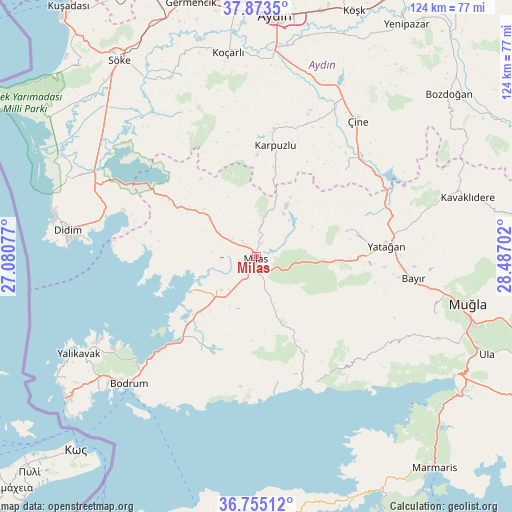
Milas GPS coordinates[2]
37° 18' 59.004" North, 27° 47' 2.004" East
| Map corner | latitude | longitude |
|---|---|---|
| Upper-left | 37.8735°, | 27.08077° |
| Center: | 37.31639°, | 27.78389° |
| Lower-right: | 36.75512°, | 28.48702° |
| Map W x H: | 124.4×124.4 km | = 77.3×77.3mi |
| max Lat: | 42.02683° ⇑79.9% North |
| Milas: | 37.31639° |
| min Lat: | ⇓20.1% South 35.9025° |
| min Long | Milas | max Long |
| 25.90902° | 27.78389° | 44.60099° |
| W 8.4%⇐ | ⇒91.6% E |
Elevation
Elevation of Milas is 52 m = 171 ft, and this is 665.4 m = 2183 ft below average elevation for this country.
| Max E: |
2682 m = 8799 ft | 87.9% |
| Avg. | 717.4 m = 2354 ft | |
| Milas | 52 m = 171 ft | |
Min E: |
0 m = 0 ft | 12.1% |
See also: Milas elevation on elevation.city.
Geographical zone
Milas is located in North temperate zone (between Tropic of Cancer and the Arctic Circle). Distance of this Northern Tropic circle is 1543.3 km =959 mi to South.| Distance of | km | miles | from Milas |
|---|---|---|---|
| North Pole | 5857.9 | 3639.9 | to North |
| Arctic Circle | 3252 | 2020.7 | to North |
| Tropic Cancer | 1543.3 | 959 | to South |
| Equator | 4149.2 | 2578.2 | to South |


Nearby cities:
15 places around Milas: (largest is in red/bold)
• Akçaova
29.8 km =18.5 mi,  45°
45°
• Bayır
38.7 km =24 mi,  98°
98°
• Bodrum
44.1 km =27.4 mi,  225°
225°
• Bozarmut
34.1 km =21.2 mi,  91°
91°
• Güvercinlik
26.8 km =16.7 mi,  221°
221°
• Karaova
25.5 km =15.8 mi,  204°
204°
• Karpuzlu
27.3 km =17 mi,  9°
9°
• Kiulukioi
18.3 km =11.4 mi,  242°
242°
• Sarıkemer
46.3 km =28.8 mi,  306°
306°
• Selimiye
14.7 km =9.1 mi, 309°
• Turgut
22.8 km =14.2 mi,  73°
73°
• Yatağan
31.8 km =19.8 mi, 85°
• Yeşilyurt
45.6 km =28.3 mi,  107°
107°
• Çine
40.9 km =25.4 mi,  36°
36°
• Ören
35.1 km =21.8 mi,  152°
152°
Sources, notices
• [Note1] Compared only with cities in Turkey existing in our database
• [Src1] Map data: © OpenStreetMap contributors (CC-BY-SA)
• [Src2] Other city data from geonames.org with taken over terms of usage.
• [Src3] Geographical zone / Annual Mean Temperature by Robert A. Rohde @ Wikipedia
