Selimiye geodata
Selimiye (Muğla) is a seat of a third-order administrative division; located in Turkey in Europe/Istanbul (GMT+3) time zone. In our database, there are 1323 cities with bigger population. Compared to other cities in Turkey, 77.4% of cities are located further ↑North; 92.6% of cities are located further →East and 87.4% of cities have higher elevation than Selimiye. Note1


Selimiye GPS coordinates[2]
37° 24' 1.26" North, 27° 39' 19.548" East
| Map corner | latitude | longitude |
|---|---|---|
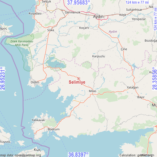
| Upper-left | 37.95683°, | 26.95231° |
| Center: | 37.40035°, | 27.65543° |
| Lower-right: | 36.8397°, | 28.35856° |
| Map W x H: | 124.2×124.2 km | = 77.2×77.2mi |
| max Lat: | 42.02683° ⇑77.4% North |
| Selimiye: | 37.40035° |
| min Lat: | ⇓22.6% South 35.9025° |
| min Long | Selimiye | max Long |
| 25.90902° | 27.65543° | 44.60099° |
| W 7.4%⇐ | ⇒92.6% E |
Elevation
Elevation of Selimiye is 55 m = 180 ft, and this is 662.4 m = 2173 ft below average elevation for this country.
| Max E: |
2682 m = 8799 ft | 87.4% |
| Avg. | 717.4 m = 2354 ft | |
| Selimiye | 55 m = 180 ft | |
Min E: |
0 m = 0 ft | 12.6% |
See also: Turkey elevation on elevation.city.
Geographical zone
Selimiye is located in North temperate zone (between Tropic of Cancer and the Arctic Circle). Distance of this Northern Tropic circle is 1552.6 km =964.7 mi to South.| Distance of | km | miles | from Selimiye |
|---|---|---|---|
| North Pole | 5848.5 | 3634.1 | to North |
| Arctic Circle | 3242.6 | 2014.9 | to North |
| Tropic Cancer | 1552.6 | 964.7 | to South |
| Equator | 4158.5 | 2584 | to South |


Nearby cities:
15 places around Selimiye: (largest is in red/bold)
• Akköy
35.5 km =22.1 mi,  286°
286°
• Akçaova
34.7 km =21.6 mi,  70°
70°
• Bağarası
35.4 km =22 mi,  344°
344°
• Didim
35.3 km =21.9 mi,  267°
267°
• Güvercinlik
30 km =18.6 mi,  192°
192°
• Karaova
32.6 km =20.3 mi,  178°
178°
• Karpuzlu
23.7 km =14.7 mi,  42°
42°
• Kiulukioi
18.5 km =11.5 mi,  195°
195°
• Koçarlı
40.4 km =25.1 mi,  6°
6°
• Milas
14.7 km =9.1 mi,  129°
129°
• Sarıkemer
31.6 km =19.6 mi,  305°
305°
• Turgut
33.3 km =20.7 mi,  94°
94°
• Yatağan
43.6 km =27.1 mi,  98°
98°
• Çakırbeyli
40.1 km =24.9 mi,  21°
21°
• Çine
42.7 km =26.5 mi,  56°
56°
Sources, notices
• [Note1] Compared only with cities in Turkey existing in our database
• [Src1] Map data: © OpenStreetMap contributors (CC-BY-SA)
• [Src2] Other city data from geonames.org with taken over terms of usage.
• [Src3] Geographical zone / Annual Mean Temperature by Robert A. Rohde @ Wikipedia
