Karaova geodata
Karaova (Muğla) is a seat of a third-order administrative division; located in Turkey in Europe/Istanbul (GMT+3) time zone. In our database, there are 1323 cities with bigger population. Compared to other cities in Turkey, 86.1% of cities are located further ↑North; 92.5% of cities are located further →East and 84.9% of cities have higher elevation than Karaova. Note1


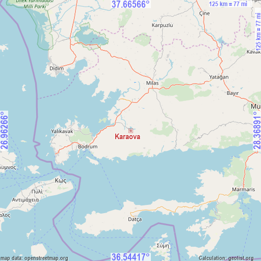
Karaova GPS coordinates[2]
37° 6' 25.164" North, 27° 39' 56.808" East
| Map corner | latitude | longitude |
|---|---|---|
| Upper-left | 37.66566°, | 26.96266° |
| Center: | 37.10699°, | 27.66578° |
| Lower-right: | 36.54417°, | 28.36891° |
| Map W x H: | 124.7×124.7 km | = 77.5×77.5mi |
| max Lat: | 42.02683° ⇑86.1% North |
| Karaova: | 37.10699° |
| min Lat: | ⇓13.9% South 35.9025° |
| min Long | Karaova | max Long |
| 25.90902° | 27.66578° | 44.60099° |
| W 7.5%⇐ | ⇒92.5% E |
Elevation
Elevation of Karaova is 72 m = 236 ft, and this is 645.4 m = 2117 ft below average elevation for this country.
| Max E: |
2682 m = 8799 ft | 84.9% |
| Avg. | 717.4 m = 2354 ft | |
| Karaova | 72 m = 236 ft | |
Min E: |
0 m = 0 ft | 15.1% |
See also: Turkey elevation on elevation.city.
Geographical zone
Karaova is located in North temperate zone (between Tropic of Cancer and the Arctic Circle). Distance of this Northern Tropic circle is 1520 km =944.5 mi to South.| Distance of | km | miles | from Karaova |
|---|---|---|---|
| North Pole | 5881.2 | 3654.4 | to North |
| Arctic Circle | 3275.3 | 2035.2 | to North |
| Tropic Cancer | 1520 | 944.5 | to South |
| Equator | 4125.9 | 2563.7 | to South |


Nearby cities:
15 places around Karaova: (largest is in red/bold)
• Bodrum
22.3 km =13.9 mi,  250°
250°
• Bozarmut
50 km =31.1 mi,  63°
63°
• Datça
41.1 km =25.5 mi,  177°
177°
• Didim
47.6 km =29.6 mi,  310°
310°
• Güvercinlik
8.2 km =5.1 mi,  294°
294°
• Karatoprak
37.6 km =23.4 mi, 253°
• Kiulukioi
15.9 km =9.9 mi,  338°
338°
• Milas
25.5 km =15.8 mi,  24°
24°
• Ortyakent Yahşi
28.9 km =18 mi,  257°
257°
• Selimiye
32.6 km =20.3 mi,  358°
358°
• Turgut
44 km =27.3 mi,  47°
47°
• Turgutreis
36.8 km =22.9 mi, 254°
• Yalıkavak
32.7 km =20.3 mi,  269°
269°
• Yatağan
49.6 km =30.8 mi, 58°
• Ören
27.9 km =17.3 mi,  106°
106°
Sources, notices
• [Note1] Compared only with cities in Turkey existing in our database
• [Src1] Map data: © OpenStreetMap contributors (CC-BY-SA)
• [Src2] Other city data from geonames.org with taken over terms of usage.
• [Src3] Geographical zone / Annual Mean Temperature by Robert A. Rohde @ Wikipedia
