Kiulukioi geodata
Kiulukioi (Muğla) is a seat of a third-order administrative division; located in Turkey in Europe/Istanbul (GMT+3) time zone. In our database, there are 1323 cities with bigger population. Compared to other cities in Turkey, 82.1% of cities are located further ↑North; 92.9% of cities are located further →East and 98.3% of cities have higher elevation than Kiulukioi. Note1


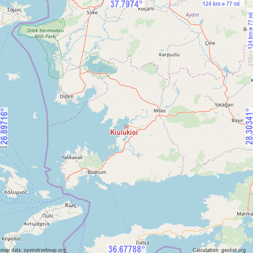
Kiulukioi GPS coordinates[2]
37° 14' 22.992" North, 27° 36' 1.008" East
| Map corner | latitude | longitude |
|---|---|---|
| Upper-left | 37.7974°, | 26.89716° |
| Center: | 37.23972°, | 27.60028° |
| Lower-right: | 36.67788°, | 28.30341° |
| Map W x H: | 124.5×124.5 km | = 77.4×77.4mi |
| max Lat: | 42.02683° ⇑82.1% North |
| Kiulukioi: | 37.23972° |
| min Lat: | ⇓17.9% South 35.9025° |
| min Long | Kiulukioi | max Long |
| 25.90902° | 27.60028° | 44.60099° |
| W 7.1%⇐ | ⇒92.9% E |
Elevation
Elevation of Kiulukioi is 9 m = 30 ft, and this is 708.4 m = 2324 ft below average elevation for this country.
| Max E: |
2682 m = 8799 ft | 98.3% |
| Avg. | 717.4 m = 2354 ft | |
| Kiulukioi | 9 m = 30 ft | |
Min E: |
0 m = 0 ft | 1.7% |
See also: Turkey elevation on elevation.city.
Geographical zone
Kiulukioi is located in North temperate zone (between Tropic of Cancer and the Arctic Circle). Distance of this Northern Tropic circle is 1534.7 km =953.6 mi to South.| Distance of | km | miles | from Kiulukioi |
|---|---|---|---|
| North Pole | 5866.4 | 3645.2 | to North |
| Arctic Circle | 3260.5 | 2026 | to North |
| Tropic Cancer | 1534.7 | 953.6 | to South |
| Equator | 4140.7 | 2572.9 | to South |


Nearby cities:
15 places around Kiulukioi: (largest is in red/bold)
• Akköy
40.5 km =25.2 mi,  313°
313°
• Bodrum
27 km =16.8 mi,  214°
214°
• Didim
34.4 km =21.4 mi,  297°
297°
• Güvercinlik
11.5 km =7.1 mi,  188°
188°
• Karaova
15.9 km =9.9 mi,  158°
158°
• Karatoprak
39.3 km =24.4 mi,  230°
230°
• Karpuzlu
41.1 km =25.5 mi,  30°
30°
• Milas
18.3 km =11.4 mi,  62°
62°
• Ortyakent Yahşi
30.8 km =19.1 mi, 226°
• Sarıkemer
41.8 km =26 mi,  330°
330°
• Selimiye
18.5 km =11.5 mi,  15°
15°
• Turgut
41 km =25.5 mi,  68°
68°
• Turgutreis
38.6 km =24 mi, 230°
• Yalıkavak
30.7 km =19.1 mi,  240°
240°
• Ören
39.6 km =24.6 mi,  124°
124°
Sources, notices
• [Note1] Compared only with cities in Turkey existing in our database
• [Src1] Map data: © OpenStreetMap contributors (CC-BY-SA)
• [Src2] Other city data from geonames.org with taken over terms of usage.
• [Src3] Geographical zone / Annual Mean Temperature by Robert A. Rohde @ Wikipedia
