Bodrum geodata
Bodrum (Muğla) is a seat of a second-order administrative division; located in Turkey in Europe/Istanbul (GMT+3) time zone. With population of 39,317 people, there are 207 cities with bigger population in this country. Compared to other cities in Turkey, 87.2% of cities are located further ↑North; 93.8% of cities are located further →East and 97.5% of cities have higher elevation than Bodrum. Note1


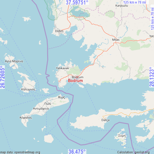
Bodrum GPS coordinates[2]
37° 2' 17.988" North, 27° 25' 45.012" East
| Map corner | latitude | longitude |
|---|---|---|
| Upper-left | 37.59751°, | 26.72605° |
| Center: | 37.03833°, | 27.42917° |
| Lower-right: | 36.475°, | 28.1323° |
| Map W x H: | 124.8×124.8 km | = 77.5×77.5mi |
| max Lat: | 42.02683° ⇑87.2% North |
| Bodrum: | 37.03833° |
| min Lat: | ⇓12.8% South 35.9025° |
| min Long | Bodrum | max Long |
| 25.90902° | 27.42917° | 44.60099° |
| W 6.2%⇐ | ⇒93.8% E |
Elevation
Elevation of Bodrum is 11 m = 36 ft, and this is 706.4 m = 2318 ft below average elevation for this country.
| Max E: |
2682 m = 8799 ft | 97.5% |
| Avg. | 717.4 m = 2354 ft | |
| Bodrum | 11 m = 36 ft | |
Min E: |
0 m = 0 ft | 2.5% |
See also: Turkey elevation on elevation.city.
Geographical zone
Bodrum is located in North temperate zone (between Tropic of Cancer and the Arctic Circle). Distance of this Northern Tropic circle is 1512.4 km =939.8 mi to South.| Distance of | km | miles | from Bodrum |
|---|---|---|---|
| North Pole | 5888.8 | 3659.1 | to North |
| Arctic Circle | 3282.9 | 2039.9 | to North |
| Tropic Cancer | 1512.4 | 939.8 | to South |
| Equator | 4118.3 | 2559 | to South |


Nearby cities:
15 places around Bodrum: (largest is in red/bold)
• Akköy
52.3 km =32.5 mi,  344°
344°
• Datça
40.4 km =25.1 mi,  145°
145°
• Didim
41.5 km =25.8 mi, 338°
• Güvercinlik
17.4 km =10.8 mi,  50°
50°
• Karaova
22.3 km =13.9 mi,  70°
70°
• Karatoprak
15.4 km =9.6 mi,  259°
259°
• Kiulukioi
27 km =16.8 mi,  34°
34°
• Milas
44.1 km =27.4 mi, 45°
• Ortyakent Yahşi
7.3 km =4.5 mi,  279°
279°
• Sarıkemer
59 km =36.7 mi,  354°
354°
• Selimiye
45 km =28 mi, 26°
• Turgut
65.1 km =40.5 mi, 54°
• Turgutreis
14.6 km =9.1 mi, 260°
• Yalıkavak
13.9 km =8.6 mi,  302°
302°
• Ören
47.8 km =29.7 mi,  90°
90°
Sources, notices
• [Note1] Compared only with cities in Turkey existing in our database
• [Src1] Map data: © OpenStreetMap contributors (CC-BY-SA)
• [Src2] Other city data from geonames.org with taken over terms of usage.
• [Src3] Geographical zone / Annual Mean Temperature by Robert A. Rohde @ Wikipedia
