Konalga geodata
Konalga (Van) is a populated place; located in Turkey in Europe/Istanbul (GMT+3) time zone. With population of 2,395 people, there are 910 cities with bigger population in this country. Compared to other cities in Turkey, 66.7% of cities are located further ↑North; 97.1% of cities are located further ←West and 98.7% of cities have lower elevation than Konalga. Note1


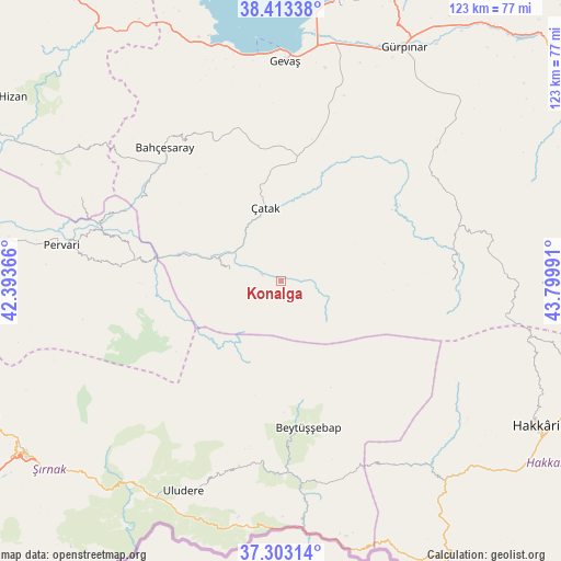
Konalga GPS coordinates[2]
37° 51' 37.26" North, 43° 5' 48.408" East
| Map corner | latitude | longitude |
|---|---|---|
| Upper-left | 38.41338°, | 42.39366° |
| Center: | 37.86035°, | 43.09678° |
| Lower-right: | 37.30314°, | 43.79991° |
| Map W x H: | 123.4×123.4 km | = 76.7×76.7mi |
| max Lat: | 42.02683° ⇑66.7% North |
| Konalga: | 37.86035° |
| min Lat: | ⇓33.3% South 35.9025° |
| min Long | Konalga | max Long |
| 25.90902° | 43.09678° | 44.60099° |
| W 97.1%⇐ | ⇒2.9% E |
Elevation
Elevation of Konalga is 1937 m = 6355 ft, and this is 1219.6 m = 4001 ft above average elevation for this country.
| Max E: |
2682 m = 8799 ft | 1.3% |
| Konalga | 1937 m 6355 ft | |
| Avg. | 717.4 m = 2354 ft | |
Min E: |
0 m = 0 ft | 98.7% |
See also: Turkey elevation on elevation.city.
Geographical zone
Konalga is located in North temperate zone (between Tropic of Cancer and the Arctic Circle). Distance of this Northern Tropic circle is 1603.8 km =996.6 mi to South.| Distance of | km | miles | from Konalga |
|---|---|---|---|
| North Pole | 5797.4 | 3602.3 | to North |
| Arctic Circle | 3191.5 | 1983.1 | to North |
| Tropic Cancer | 1603.8 | 996.6 | to South |
| Equator | 4209.7 | 2615.8 | to South |


Nearby cities:
15 places around Konalga: (largest is in red/bold)
• Atlıhan
25 km =15.5 mi,  285°
285°
• Belenoluk
28.7 km =17.8 mi,  282°
282°
• Beytüşşebap
33.6 km =20.9 mi,  169°
169°
• Buğdaylı
22.7 km =14.1 mi,  148°
148°
• Doğanköy
29.1 km =18.1 mi,  248°
248°
• Karchane
27.1 km =16.8 mi, 172°
• Kaçıt
12.3 km =7.6 mi,  309°
309°
• Mezraa
23.4 km =14.5 mi,  159°
159°
• Narlı
10.9 km =6.8 mi, 284°
• Sözveren
14.6 km =9.1 mi,  353°
353°
• Uzyum
37 km =23 mi, 294°
• Yalınca
37.4 km =23.2 mi,  90°
90°
• Yapraktepe
27.8 km =17.3 mi,  260°
260°
• Çatak
16.3 km =10.1 mi, 346°
• Övecek
19.3 km =12 mi, 284°
Sources, notices
• [Note1] Compared only with cities in Turkey existing in our database
• [Src1] Map data: © OpenStreetMap contributors (CC-BY-SA)
• [Src2] Other city data from geonames.org with taken over terms of usage.
• [Src3] Geographical zone / Annual Mean Temperature by Robert A. Rohde @ Wikipedia
