Kütahya geodata
Kütahya is a seat of a first-order administrative division; located in Turkey in Europe/Istanbul (GMT+3) time zone. With population of 185,008 people, there are 54 cities with bigger population in this country. Compared to other cities in Turkey, 60.2% of cities are located further ↓South; 75.9% of cities are located further →East and 64.1% of cities have lower elevation than Kütahya. Note1


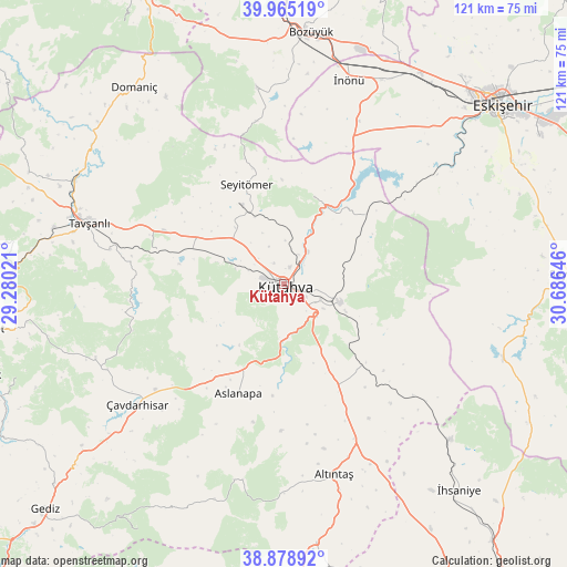
Kütahya GPS coordinates[2]
39° 25' 27.012" North, 29° 58' 59.988" East
| Map corner | latitude | longitude |
|---|---|---|
| Upper-left | 39.96519°, | 29.28021° |
| Center: | 39.42417°, | 29.98333° |
| Lower-right: | 38.87892°, | 30.68646° |
| Map W x H: | 120.8×120.8 km | = 75.1×75.1mi |
| max Lat: | 42.02683° ⇑39.8% North |
| Kütahya: | 39.42417° |
| min Lat: | ⇓60.2% South 35.9025° |
| min Long | Kütahya | max Long |
| 25.90902° | 29.98333° | 44.60099° |
| W 24.1%⇐ | ⇒75.9% E |
Elevation
Elevation of Kütahya is 947 m = 3107 ft, and this is 229.6 m = 753 ft above average elevation for this country.
| Max E: |
2682 m = 8799 ft | 35.9% |
| Kütahya | 947 m 3107 ft | |
| Avg. | 717.4 m = 2354 ft | |
Min E: |
0 m = 0 ft | 64.1% |
See also: Kütahya elevation on elevation.city.
Geographical zone
Kütahya is located in North temperate zone (between Tropic of Cancer and the Arctic Circle). Distance of this Northern Tropic circle is 1777.6 km =1104.5 mi to South.| Distance of | km | miles | from Kütahya |
|---|---|---|---|
| North Pole | 5623.5 | 3494.3 | to North |
| Arctic Circle | 3017.6 | 1875 | to North |
| Tropic Cancer | 1777.6 | 1104.5 | to South |
| Equator | 4383.6 | 2723.8 | to South |


Nearby cities:
15 places around Kütahya: (largest is in red/bold)
• Altıntaş
41.9 km =26 mi,  165°
165°
• Aslanapa
25.1 km =15.6 mi,  202°
202°
• Bozüyük
54 km =33.6 mi,  4°
4°
• Dodurga
42.1 km =26.2 mi,  352°
352°
• Domaniç
52.8 km =32.8 mi,  322°
322°
• Eskişehir
60.5 km =37.6 mi,  49°
49°
• Köprüören
21.2 km =13.2 mi,  296°
296°
• Kırka
49.4 km =30.7 mi,  109°
109°
• Odunpazarı
60.8 km =37.8 mi, 51°
• Sabuncu
23.3 km =14.5 mi, 49°
• Tavşanlı
43.6 km =27.1 mi,  287°
287°
• Çavdarhisar
40.5 km =25.2 mi,  230°
230°
• Örencik
41.8 km =26 mi,  244°
244°
• İhsaniye
57.6 km =35.8 mi,  139°
139°
• İnönü
45.7 km =28.4 mi,  17°
17°
Sources, notices
• [Note1] Compared only with cities in Turkey existing in our database
• [Src1] Map data: © OpenStreetMap contributors (CC-BY-SA)
• [Src2] Other city data from geonames.org with taken over terms of usage.
• [Src3] Geographical zone / Annual Mean Temperature by Robert A. Rohde @ Wikipedia
