Aslanapa geodata
Aslanapa (Kütahya) is a seat of a second-order administrative division; located in Turkey in Europe/Istanbul (GMT+3) time zone. With population of 2,388 people, there are 911 cities with bigger population in this country. Compared to other cities in Turkey, 57.5% of cities are located further ↓South; 76.7% of cities are located further →East and 70% of cities have lower elevation than Aslanapa. Note1


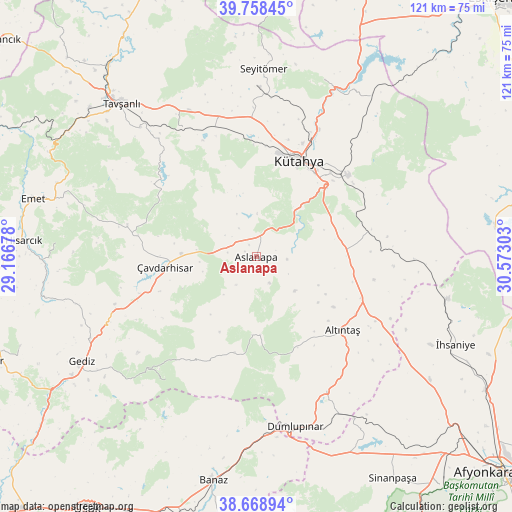
Aslanapa GPS coordinates[2]
39° 12' 56.916" North, 29° 52' 11.64" East
| Map corner | latitude | longitude |
|---|---|---|
| Upper-left | 39.75845°, | 29.16678° |
| Center: | 39.21581°, | 29.8699° |
| Lower-right: | 38.66894°, | 30.57303° |
| Map W x H: | 121.1×121.1 km | = 75.2×75.2mi |
| max Lat: | 42.02683° ⇑42.5% North |
| Aslanapa: | 39.21581° |
| min Lat: | ⇓57.5% South 35.9025° |
| min Long | Aslanapa | max Long |
| 25.90902° | 29.8699° | 44.60099° |
| W 23.3%⇐ | ⇒76.7% E |
Elevation
Elevation of Aslanapa is 1030 m = 3379 ft, and this is 312.6 m = 1026 ft above average elevation for this country.
| Max E: |
2682 m = 8799 ft | 30% |
| Aslanapa | 1030 m 3379 ft | |
| Avg. | 717.4 m = 2354 ft | |
Min E: |
0 m = 0 ft | 70% |
See also: Turkey elevation on elevation.city.
Geographical zone
Aslanapa is located in North temperate zone (between Tropic of Cancer and the Arctic Circle). Distance of this Northern Tropic circle is 1754.5 km =1090.2 mi to South.| Distance of | km | miles | from Aslanapa |
|---|---|---|---|
| North Pole | 5646.7 | 3508.7 | to North |
| Arctic Circle | 3040.8 | 1889.5 | to North |
| Tropic Cancer | 1754.5 | 1090.2 | to South |
| Equator | 4360.4 | 2709.4 | to South |


Nearby cities:
15 places around Aslanapa: (largest is in red/bold)
• Altıntaş
27 km =16.8 mi,  130°
130°
• Banaz
54.2 km =33.7 mi,  190°
190°
• Dumlupınar
41.3 km =25.7 mi,  167°
167°
• Emet
54.5 km =33.9 mi,  285°
285°
• Gediz
48.1 km =29.9 mi,  239°
239°
• Hisarcık
55.1 km =34.2 mi,  274°
274°
• Köprüören
33.8 km =21 mi,  344°
344°
• Kütahya
25.1 km =15.6 mi,  22°
22°
• Kırka
57 km =35.4 mi,  82°
82°
• Sabuncu
47.2 km =29.3 mi,  35°
35°
• Tavşanlı
48.3 km =30 mi,  318°
318°
• Çavdarhisar
21.7 km =13.5 mi,  263°
263°
• Örencik
28.6 km =17.8 mi,  280°
280°
• İhsaniye
51.5 km =32 mi,  113°
113°
• Şaphane
59.7 km =37.1 mi,  249°
249°
Sources, notices
• [Note1] Compared only with cities in Turkey existing in our database
• [Src1] Map data: © OpenStreetMap contributors (CC-BY-SA)
• [Src2] Other city data from geonames.org with taken over terms of usage.
• [Src3] Geographical zone / Annual Mean Temperature by Robert A. Rohde @ Wikipedia
