Altıntaş geodata
Altıntaş (Kütahya) is a seat of a second-order administrative division; located in Turkey in Europe/Istanbul (GMT+3) time zone. In our database, there are 1323 cities with bigger population. Compared to other cities in Turkey, 55.3% of cities are located further ↓South; 75.3% of cities are located further →East and 70.5% of cities have lower elevation than Altıntaş. Note1


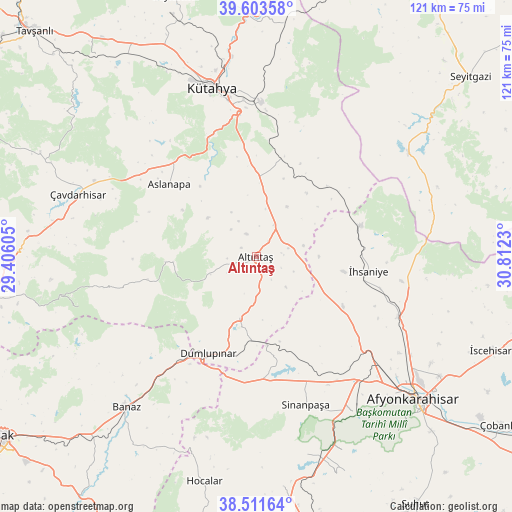
Altıntaş GPS coordinates[2]
39° 3' 34.992" North, 30° 6' 33.012" East
| Map corner | latitude | longitude |
|---|---|---|
| Upper-left | 39.60358°, | 29.40605° |
| Center: | 39.05972°, | 30.10917° |
| Lower-right: | 38.51164°, | 30.8123° |
| Map W x H: | 121.4×121.4 km | = 75.4×75.4mi |
| max Lat: | 42.02683° ⇑44.7% North |
| Altıntaş: | 39.05972° |
| min Lat: | ⇓55.3% South 35.9025° |
| min Long | Altıntaş | max Long |
| 25.90902° | 30.10917° | 44.60099° |
| W 24.7%⇐ | ⇒75.3% E |
Elevation
Elevation of Altıntaş is 1033 m = 3389 ft, and this is 315.6 m = 1035 ft above average elevation for this country.
| Max E: |
2682 m = 8799 ft | 29.5% |
| Altıntaş | 1033 m 3389 ft | |
| Avg. | 717.4 m = 2354 ft | |
Min E: |
0 m = 0 ft | 70.5% |
See also: Turkey elevation on elevation.city.
Geographical zone
Altıntaş is located in North temperate zone (between Tropic of Cancer and the Arctic Circle). Distance of this Northern Tropic circle is 1737.1 km =1079.4 mi to South.| Distance of | km | miles | from Altıntaş |
|---|---|---|---|
| North Pole | 5664 | 3519.4 | to North |
| Arctic Circle | 3058.1 | 1900.2 | to North |
| Tropic Cancer | 1737.1 | 1079.4 | to South |
| Equator | 4343 | 2698.6 | to South |


Nearby cities:
15 places around Altıntaş: (largest is in red/bold)
• Afyonkarahisar
50.5 km =31.4 mi,  131°
131°
• Aslanapa
27 km =16.8 mi,  310°
310°
• Banaz
47.4 km =29.5 mi,  220°
220°
• Dumlupınar
25.6 km =15.9 mi,  206°
206°
• Hocalar
54.9 km =34.1 mi,  192°
192°
• Karadirek
55 km =34.2 mi,  173°
173°
• Köprüören
58.1 km =36.1 mi,  329°
329°
• Kütahya
41.9 km =26 mi,  345°
345°
• Kırka
43.5 km =27 mi,  55°
55°
• Kızılcasöğüt
59.5 km =37 mi, 220°
• Sabuncu
56.2 km =34.9 mi,  6°
6°
• Sinanpaşa
36.9 km =22.9 mi,  161°
161°
• Çavdarhisar
44.8 km =27.8 mi,  289°
289°
• Örencik
53.7 km =33.4 mi, 294°
• İhsaniye
26.7 km =16.6 mi,  97°
97°
Sources, notices
• [Note1] Compared only with cities in Turkey existing in our database
• [Src1] Map data: © OpenStreetMap contributors (CC-BY-SA)
• [Src2] Other city data from geonames.org with taken over terms of usage.
• [Src3] Geographical zone / Annual Mean Temperature by Robert A. Rohde @ Wikipedia
