Kumlu geodata
Kumlu (Hatay) is a seat of a second-order administrative division; located in Turkey in Europe/Istanbul (GMT+3) time zone. In our database, there are 1323 cities with bigger population. Compared to other cities in Turkey, 97.4% of cities are located further ↑North; 54.5% of cities are located further ←West and 82.4% of cities have higher elevation than Kumlu. Note1


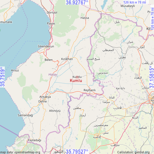
Kumlu GPS coordinates[2]
36° 21' 48.708" North, 36° 27' 18.072" East
| Map corner | latitude | longitude |
|---|---|---|
| Upper-left | 36.92767°, | 35.7519° |
| Center: | 36.36353°, | 36.45502° |
| Lower-right: | 35.79527°, | 37.15815° |
| Map W x H: | 125.9×125.9 km | = 78.2×78.2mi |
| max Lat: | 42.02683° ⇑97.4% North |
| Kumlu: | 36.36353° |
| min Lat: | ⇓2.6% South 35.9025° |
| min Long | Kumlu | max Long |
| 25.90902° | 36.45502° | 44.60099° |
| W 54.5%⇐ | ⇒45.5% E |
Elevation
Elevation of Kumlu is 91 m = 299 ft, and this is 626.4 m = 2055 ft below average elevation for this country.
| Max E: |
2682 m = 8799 ft | 82.4% |
| Avg. | 717.4 m = 2354 ft | |
| Kumlu | 91 m = 299 ft | |
Min E: |
0 m = 0 ft | 17.6% |
See also: Turkey elevation on elevation.city.
Geographical zone
Kumlu is located in North temperate zone (between Tropic of Cancer and the Arctic Circle). Distance of this Northern Tropic circle is 1437.3 km =893.1 mi to South.| Distance of | km | miles | from Kumlu |
|---|---|---|---|
| North Pole | 5963.8 | 3705.7 | to North |
| Arctic Circle | 3357.9 | 2086.5 | to North |
| Tropic Cancer | 1437.3 | 893.1 | to South |
| Equator | 4043.2 | 2512.3 | to South |


Nearby cities:
15 places around Kumlu: (largest is in red/bold)
• Anayazı
24.1 km =15 mi,  258°
258°
• Atayurdu
25.7 km =16 mi,  217°
217°
• Açıkdere
23.7 km =14.7 mi,  227°
227°
• Boynuyoğun
23.8 km =14.8 mi,  205°
205°
• Büyük Dalyan
23.6 km =14.7 mi,  249°
249°
• Demirkonak
25.2 km =15.7 mi,  14°
14°
• Karasüleymanlı
4.4 km =2.7 mi,  236°
236°
• Kastal
23.1 km =14.4 mi, 236°
• Kırıkhan
17.4 km =10.8 mi,  330°
330°
• Mansurlu
25.6 km =15.9 mi, 231°
• Reyhanlı
14.6 km =9.1 mi,  136°
136°
• Serinyol
21.6 km =13.4 mi,  269°
269°
• Uzunkavak
3.4 km =2.1 mi, 248°
• Yalangöz
24.2 km =15 mi, 11°
• Yeşilova
20.8 km =12.9 mi, 239°
Sources, notices
• [Note1] Compared only with cities in Turkey existing in our database
• [Src1] Map data: © OpenStreetMap contributors (CC-BY-SA)
• [Src2] Other city data from geonames.org with taken over terms of usage.
• [Src3] Geographical zone / Annual Mean Temperature by Robert A. Rohde @ Wikipedia
