Reyhanlı geodata
Reyhanlı (Hatay) is a seat of a second-order administrative division; located in Turkey in Europe/Istanbul (GMT+3) time zone. With population of 56,995 people, there are 153 cities with bigger population in this country. Compared to other cities in Turkey, 98% of cities are located further ↑North; 55.1% of cities are located further ←West and 76.6% of cities have higher elevation than Reyhanlı. Note1


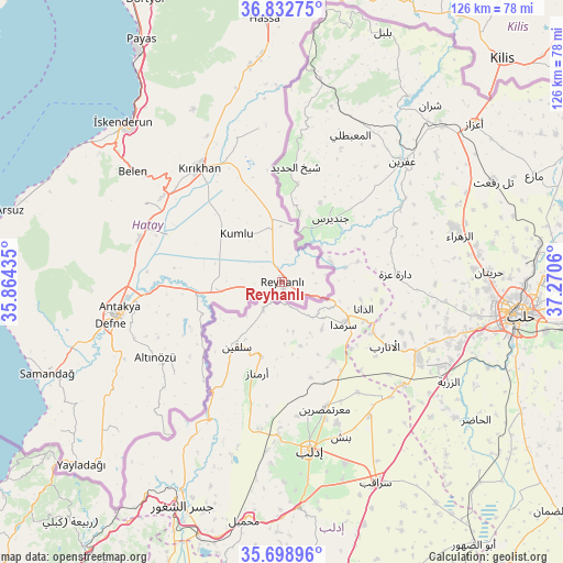
Reyhanlı GPS coordinates[2]
36° 16' 4.476" North, 36° 34' 2.892" East
| Map corner | latitude | longitude |
|---|---|---|
| Upper-left | 36.83275°, | 35.86435° |
| Center: | 36.26791°, | 36.56747° |
| Lower-right: | 35.69896°, | 37.2706° |
| Map W x H: | 126.1×126.1 km | = 78.4×78.4mi |
| max Lat: | 42.02683° ⇑98% North |
| Reyhanlı: | 36.26791° |
| min Lat: | ⇓2% South 35.9025° |
| min Long | Reyhanlı | max Long |
| 25.90902° | 36.56747° | 44.60099° |
| W 55.1%⇐ | ⇒44.9% E |
Elevation
Elevation of Reyhanlı is 153 m = 502 ft, and this is 564.4 m = 1852 ft below average elevation for this country.
| Max E: |
2682 m = 8799 ft | 76.6% |
| Avg. | 717.4 m = 2354 ft | |
| Reyhanlı | 153 m = 502 ft | |
Min E: |
0 m = 0 ft | 23.4% |
See also: Reyhanlı elevation on elevation.city.
Geographical zone
Reyhanlı is located in North temperate zone (between Tropic of Cancer and the Arctic Circle). Distance of this Northern Tropic circle is 1426.7 km =886.5 mi to South.| Distance of | km | miles | from Reyhanlı |
|---|---|---|---|
| North Pole | 5974.4 | 3712.3 | to North |
| Arctic Circle | 3368.6 | 2093.2 | to North |
| Tropic Cancer | 1426.7 | 886.5 | to South |
| Equator | 4032.6 | 2505.7 | to South |


Nearby cities:
15 places around Reyhanlı: (largest is in red/bold)
• Atayurdu
27.6 km =17.1 mi,  249°
249°
• Açıkdere
28.1 km =17.5 mi,  258°
258°
• Babatorun
32.7 km =20.3 mi,  229°
229°
• Boynuyoğun
23 km =14.3 mi,  241°
241°
• Büyük Dalyan
32.2 km =20 mi,  274°
274°
• Hacıpaşa
28.3 km =17.6 mi,  218°
218°
• Karasüleymanlı
16 km =9.9 mi,  300°
300°
• Kastal
29.4 km =18.3 mi, 265°
• Kumlu
14.6 km =9.1 mi,  316°
316°
• Kırıkhan
31.9 km =19.8 mi, 323°
• Mansurlu
30.6 km =19 mi, 260°
• Serinyol
33.4 km =20.8 mi,  288°
288°
• Tepehan
32.7 km =20.3 mi, 248°
• Uzunkavak
16.2 km =10.1 mi,  305°
305°
• Yeşilova
28.1 km =17.5 mi, 270°
Sources, notices
• [Note1] Compared only with cities in Turkey existing in our database
• [Src1] Map data: © OpenStreetMap contributors (CC-BY-SA)
• [Src2] Other city data from geonames.org with taken over terms of usage.
• [Src3] Geographical zone / Annual Mean Temperature by Robert A. Rohde @ Wikipedia
