Sille geodata
Sille (Konya) is a seat of a third-order administrative division; located in Turkey in Europe/Istanbul (GMT+3) time zone. In our database, there are 1323 cities with bigger population. Compared to other cities in Turkey, 63.5% of cities are located further ↑North; 64.8% of cities are located further →East and 79.1% of cities have lower elevation than Sille. Note1


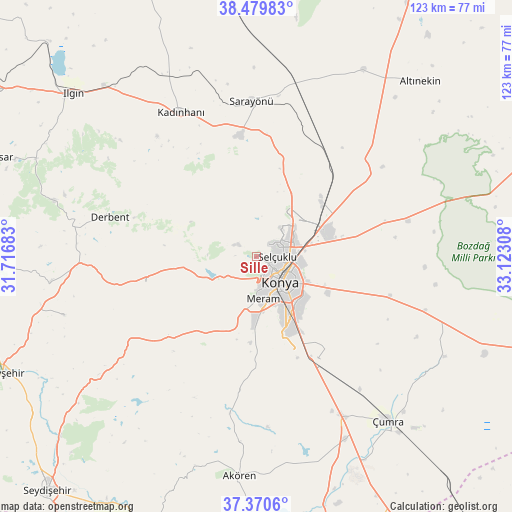
Sille GPS coordinates[2]
37° 55' 38.316" North, 32° 25' 11.82" East
| Map corner | latitude | longitude |
|---|---|---|
| Upper-left | 38.47983°, | 31.71683° |
| Center: | 37.92731°, | 32.41995° |
| Lower-right: | 37.3706°, | 33.12308° |
| Map W x H: | 123.3×123.3 km | = 76.6×76.6mi |
| max Lat: | 42.02683° ⇑63.5% North |
| Sille: | 37.92731° |
| min Lat: | ⇓36.5% South 35.9025° |
| min Long | Sille | max Long |
| 25.90902° | 32.41995° | 44.60099° |
| W 35.2%⇐ | ⇒64.8% E |
Elevation
Elevation of Sille is 1177 m = 3862 ft, and this is 459.6 m = 1508 ft above average elevation for this country.
| Max E: |
2682 m = 8799 ft | 20.9% |
| Sille | 1177 m 3862 ft | |
| Avg. | 717.4 m = 2354 ft | |
Min E: |
0 m = 0 ft | 79.1% |
See also: Turkey elevation on elevation.city.
Geographical zone
Sille is located in North temperate zone (between Tropic of Cancer and the Arctic Circle). Distance of this Northern Tropic circle is 1611.2 km =1001.2 mi to South.| Distance of | km | miles | from Sille |
|---|---|---|---|
| North Pole | 5789.9 | 3597.7 | to North |
| Arctic Circle | 3184.1 | 1978.5 | to North |
| Tropic Cancer | 1611.2 | 1001.2 | to South |
| Equator | 4217.1 | 2620.4 | to South |


Nearby cities:
15 places around Sille: (largest is in red/bold)
• Aşağıpınarbaşı
20.1 km =12.5 mi,  52°
52°
• Derbent
36.7 km =22.8 mi,  285°
285°
• Doğanbey
48.5 km =30.1 mi,  253°
253°
• Hatip
19.2 km =11.9 mi,  179°
179°
• Hatunsaray
38.3 km =23.8 mi,  189°
189°
• Kadınhanı
39.2 km =24.4 mi,  332°
332°
• Karatay
11.6 km =7.2 mi,  124°
124°
• Konya
8.4 km =5.2 mi,  137°
137°
• Kurthasanlı
49.2 km =30.6 mi, 334°
• Kızılören
27.4 km =17 mi,  256°
256°
• Meram
11.6 km =7.2 mi,  158°
158°
• Sarayönü
37.2 km =23.1 mi,  357°
357°
• Selçuklu
7.9 km =4.9 mi,  127°
127°
• Yarma
42.6 km =26.5 mi,  107°
107°
• Çatalhöyük
45.9 km =28.5 mi, 128°
Sources, notices
• [Note1] Compared only with cities in Turkey existing in our database
• [Src1] Map data: © OpenStreetMap contributors (CC-BY-SA)
• [Src2] Other city data from geonames.org with taken over terms of usage.
• [Src3] Geographical zone / Annual Mean Temperature by Robert A. Rohde @ Wikipedia
