Selçuklu geodata
Selçuklu (Konya) is a seat of a second-order administrative division; located in Turkey in Europe/Istanbul (GMT+3) time zone. In our database, there are 1323 cities with bigger population. Compared to other cities in Turkey, 65.7% of cities are located further ↑North; 64.4% of cities are located further →East and 69.5% of cities have lower elevation than Selçuklu. Note1


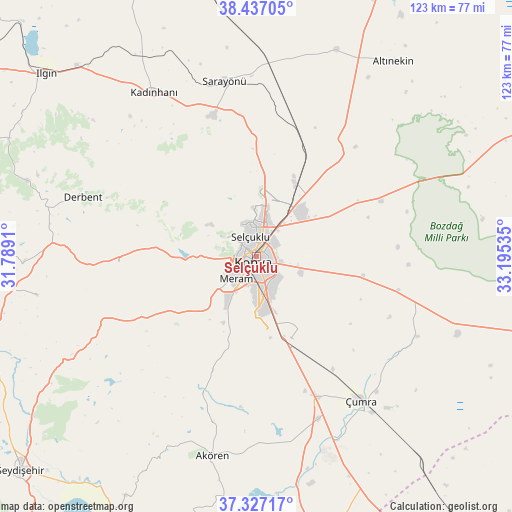
Selçuklu GPS coordinates[2]
37° 53' 3.12" North, 32° 29' 31.992" East
| Map corner | latitude | longitude |
|---|---|---|
| Upper-left | 38.43705°, | 31.7891° |
| Center: | 37.8842°, | 32.49222° |
| Lower-right: | 37.32717°, | 33.19535° |
| Map W x H: | 123.4×123.4 km | = 76.7×76.7mi |
| max Lat: | 42.02683° ⇑65.7% North |
| Selçuklu: | 37.8842° |
| min Lat: | ⇓34.3% South 35.9025° |
| min Long | Selçuklu | max Long |
| 25.90902° | 32.49222° | 44.60099° |
| W 35.6%⇐ | ⇒64.4% E |
Elevation
Elevation of Selçuklu is 1020 m = 3346 ft, and this is 302.6 m = 993 ft above average elevation for this country.
| Max E: |
2682 m = 8799 ft | 30.5% |
| Selçuklu | 1020 m 3346 ft | |
| Avg. | 717.4 m = 2354 ft | |
Min E: |
0 m = 0 ft | 69.5% |
See also: Turkey elevation on elevation.city.
Geographical zone
Selçuklu is located in North temperate zone (between Tropic of Cancer and the Arctic Circle). Distance of this Northern Tropic circle is 1606.4 km =998.2 mi to South.| Distance of | km | miles | from Selçuklu |
|---|---|---|---|
| North Pole | 5794.7 | 3600.7 | to North |
| Arctic Circle | 3188.8 | 1981.4 | to North |
| Tropic Cancer | 1606.4 | 998.2 | to South |
| Equator | 4212.3 | 2617.4 | to South |


Nearby cities:
15 places around Selçuklu: (largest is in red/bold)
• Aşağıpınarbaşı
19.6 km =12.2 mi,  29°
29°
• Derbent
44.2 km =27.5 mi,  289°
289°
• Hatip
15.7 km =9.8 mi,  203°
203°
• Hatunsaray
35.3 km =21.9 mi, 201°
• Kadınhanı
46.6 km =29 mi,  328°
328°
• Karatay
3.7 km =2.3 mi,  120°
120°
• Konya
1.6 km =1 mi, 204°
• Kızılören
33 km =20.5 mi,  266°
266°
• Meram
6.4 km =4 mi, 199°
• Ovakavağı
43.4 km =27 mi, 116°
• Sarayönü
42.7 km =26.5 mi,  349°
349°
• Sille
7.9 km =4.9 mi,  307°
307°
• Yarma
35.2 km =21.9 mi,  103°
103°
• Çatalhöyük
38 km =23.6 mi,  129°
129°
• Çumra
42.6 km =26.5 mi,  144°
144°
Sources, notices
• [Note1] Compared only with cities in Turkey existing in our database
• [Src1] Map data: © OpenStreetMap contributors (CC-BY-SA)
• [Src2] Other city data from geonames.org with taken over terms of usage.
• [Src3] Geographical zone / Annual Mean Temperature by Robert A. Rohde @ Wikipedia
