Meram geodata
Meram (Konya) is a seat of a second-order administrative division; located in Turkey in Europe/Istanbul (GMT+3) time zone. In our database, there are 1323 cities with bigger population. Compared to other cities in Turkey, 67.6% of cities are located further ↑North; 64.6% of cities are located further →East and 70% of cities have lower elevation than Meram. Note1


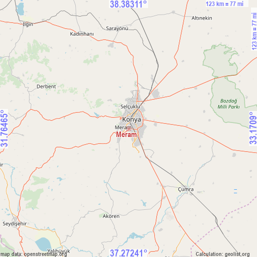
Meram GPS coordinates[2]
37° 49' 47.46" North, 32° 28' 3.972" East
| Map corner | latitude | longitude |
|---|---|---|
| Upper-left | 38.38311°, | 31.76465° |
| Center: | 37.82985°, | 32.46777° |
| Lower-right: | 37.27241°, | 33.1709° |
| Map W x H: | 123.5×123.5 km | = 76.7×76.7mi |
| max Lat: | 42.02683° ⇑67.6% North |
| Meram: | 37.82985° |
| min Lat: | ⇓32.4% South 35.9025° |
| min Long | Meram | max Long |
| 25.90902° | 32.46777° | 44.60099° |
| W 35.4%⇐ | ⇒64.6% E |
Elevation
Elevation of Meram is 1030 m = 3379 ft, and this is 312.6 m = 1026 ft above average elevation for this country.
| Max E: |
2682 m = 8799 ft | 30% |
| Meram | 1030 m 3379 ft | |
| Avg. | 717.4 m = 2354 ft | |
Min E: |
0 m = 0 ft | 70% |
See also: Turkey elevation on elevation.city.
Geographical zone
Meram is located in North temperate zone (between Tropic of Cancer and the Arctic Circle). Distance of this Northern Tropic circle is 1600.4 km =994.4 mi to South.| Distance of | km | miles | from Meram |
|---|---|---|---|
| North Pole | 5800.8 | 3604.4 | to North |
| Arctic Circle | 3194.9 | 1985.2 | to North |
| Tropic Cancer | 1600.4 | 994.4 | to South |
| Equator | 4206.3 | 2613.7 | to South |


Nearby cities:
15 places around Meram: (largest is in red/bold)
• Akören
42.7 km =26.5 mi,  191°
191°
• Aşağıpınarbaşı
26 km =16.2 mi,  26°
26°
• Derbent
44.6 km =27.7 mi,  297°
297°
• Hatip
9.3 km =5.8 mi,  205°
205°
• Hatunsaray
28.9 km =18 mi,  201°
201°
• Karatay
6.8 km =4.2 mi,  52°
52°
• Konya
4.8 km =3 mi,  17°
17°
• Kızılören
31.2 km =19.4 mi,  277°
277°
• Ovakavağı
43.1 km =26.8 mi,  107°
107°
• Sarayönü
48.4 km =30.1 mi,  353°
353°
• Selçuklu
6.4 km =4 mi, 19°
• Sille
11.6 km =7.2 mi,  338°
338°
• Yarma
36.5 km =22.7 mi,  93°
93°
• Çatalhöyük
36.3 km =22.6 mi,  119°
119°
• Çumra
39.3 km =24.4 mi,  136°
136°
Sources, notices
• [Note1] Compared only with cities in Turkey existing in our database
• [Src1] Map data: © OpenStreetMap contributors (CC-BY-SA)
• [Src2] Other city data from geonames.org with taken over terms of usage.
• [Src3] Geographical zone / Annual Mean Temperature by Robert A. Rohde @ Wikipedia
