Kale geodata
Kale (Denizli) is a seat of a second-order administrative division; located in Turkey in Europe/Istanbul (GMT+3) time zone. With population of 7,255 people, there are 606 cities with bigger population in this country. Compared to other cities in Turkey, 76.4% of cities are located further ↑North; 85.2% of cities are located further →East and 72.2% of cities have lower elevation than Kale. Note1


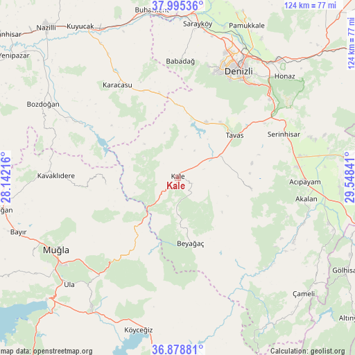
Kale GPS coordinates[2]
37° 26' 21.012" North, 28° 50' 43.008" East
| Map corner | latitude | longitude |
|---|---|---|
| Upper-left | 37.99536°, | 28.14216° |
| Center: | 37.43917°, | 28.84528° |
| Lower-right: | 36.87881°, | 29.54841° |
| Map W x H: | 124.1×124.1 km | = 77.1×77.1mi |
| max Lat: | 42.02683° ⇑76.4% North |
| Kale: | 37.43917° |
| min Lat: | ⇓23.6% South 35.9025° |
| min Long | Kale | max Long |
| 25.90902° | 28.84528° | 44.60099° |
| W 14.8%⇐ | ⇒85.2% E |
Elevation
Elevation of Kale is 1059 m = 3474 ft, and this is 341.6 m = 1121 ft above average elevation for this country.
| Max E: |
2682 m = 8799 ft | 27.8% |
| Kale | 1059 m 3474 ft | |
| Avg. | 717.4 m = 2354 ft | |
Min E: |
0 m = 0 ft | 72.2% |
See also: Turkey elevation on elevation.city.
Geographical zone
Kale is located in North temperate zone (between Tropic of Cancer and the Arctic Circle). Distance of this Northern Tropic circle is 1556.9 km =967.4 mi to South.| Distance of | km | miles | from Kale |
|---|---|---|---|
| North Pole | 5844.2 | 3631.4 | to North |
| Arctic Circle | 3238.3 | 2012.2 | to North |
| Tropic Cancer | 1556.9 | 967.4 | to South |
| Equator | 4162.8 | 2586.6 | to South |


Nearby cities:
15 places around Kale: (largest is in red/bold)
• Acıpayam
44.5 km =27.7 mi,  92°
92°
• Babadağ
41 km =25.5 mi,  1°
1°
• Beyağaç
23.1 km =14.4 mi,  168°
168°
• Denizli
42.9 km =26.7 mi,  29°
29°
• Göktepe
25.4 km =15.8 mi,  264°
264°
• Karacasu
38.4 km =23.9 mi,  326°
326°
• Kavaklıdere
42.6 km =26.5 mi,  270°
270°
• Kelekçi
46.2 km =28.7 mi,  118°
118°
• Kızılcabölük
24.5 km =15.2 mi,  38°
38°
• Merkezefendi
44.3 km =27.5 mi,  23°
23°
• Muğla
49 km =30.4 mi,  239°
239°
• Nikfer
26.1 km =16.2 mi,  98°
98°
• Pamukkale
45.2 km =28.1 mi, 29°
• Serinhisar
40.4 km =25.1 mi,  66°
66°
• Tavas
24.9 km =15.5 mi,  53°
53°
Sources, notices
• [Note1] Compared only with cities in Turkey existing in our database
• [Src1] Map data: © OpenStreetMap contributors (CC-BY-SA)
• [Src2] Other city data from geonames.org with taken over terms of usage.
• [Src3] Geographical zone / Annual Mean Temperature by Robert A. Rohde @ Wikipedia
