Yedisu geodata
Yedisu (Bingöl) is a seat of a second-order administrative division; located in Turkey in Europe/Istanbul (GMT+3) time zone. With population of 1,771 people, there are 981 cities with bigger population in this country. Compared to other cities in Turkey, 60.3% of cities are located further ↓South; 76.6% of cities are located further ←West and 89.2% of cities have lower elevation than Yedisu. Note1


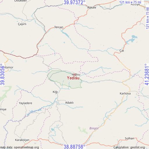
Yedisu GPS coordinates[2]
39° 25' 57.972" North, 40° 32' 1.248" East
| Map corner | latitude | longitude |
|---|---|---|
| Upper-left | 39.97372°, | 39.83056° |
| Center: | 39.43277°, | 40.53368° |
| Lower-right: | 38.88758°, | 41.23681° |
| Map W x H: | 120.8×120.8 km | = 75.1×75.1mi |
| max Lat: | 42.02683° ⇑39.7% North |
| Yedisu: | 39.43277° |
| min Lat: | ⇓60.3% South 35.9025° |
| min Long | Yedisu | max Long |
| 25.90902° | 40.53368° | 44.60099° |
| W 76.6%⇐ | ⇒23.4% E |
Elevation
Elevation of Yedisu is 1437 m = 4715 ft, and this is 719.6 m = 2361 ft above average elevation for this country.
| Max E: |
2682 m = 8799 ft | 10.8% |
| Yedisu | 1437 m 4715 ft | |
| Avg. | 717.4 m = 2354 ft | |
Min E: |
0 m = 0 ft | 89.2% |
See also: Turkey elevation on elevation.city.
Geographical zone
Yedisu is located in North temperate zone (between Tropic of Cancer and the Arctic Circle). Distance of this Northern Tropic circle is 1778.6 km =1105.2 mi to South.| Distance of | km | miles | from Yedisu |
|---|---|---|---|
| North Pole | 5622.5 | 3493.7 | to North |
| Arctic Circle | 3016.7 | 1874.5 | to North |
| Tropic Cancer | 1778.6 | 1105.2 | to South |
| Equator | 4384.5 | 2724.4 | to South |


Nearby cities:
15 places around Yedisu: (largest is in red/bold)
• Adaklı
23.4 km =14.5 mi,  190°
190°
• Balpayam
41 km =25.5 mi,  268°
268°
• Dağyolu
55 km =34.2 mi,  282°
282°
• Göynük
43.9 km =27.3 mi,  138°
138°
• Ilıcalar
51.7 km =32.1 mi,  166°
166°
• Karlıova
43.6 km =27.1 mi,  111°
111°
• Kasaba
20.6 km =12.8 mi,  229°
229°
• Pulumer
55.1 km =34.2 mi, 275°
• Sancak
39.9 km =24.8 mi,  198°
198°
• Tercan
40.5 km =25.2 mi,  340°
340°
• Yayladere
46.1 km =28.6 mi,  240°
240°
• Çan
42.5 km =26.4 mi,  221°
221°
• Çat
42 km =26.1 mi,  62°
62°
• Çiftlik
39.9 km =24.8 mi,  12°
12°
• Üçdam
34 km =21.1 mi,  295°
295°
Sources, notices
• [Note1] Compared only with cities in Turkey existing in our database
• [Src1] Map data: © OpenStreetMap contributors (CC-BY-SA)
• [Src2] Other city data from geonames.org with taken over terms of usage.
• [Src3] Geographical zone / Annual Mean Temperature by Robert A. Rohde @ Wikipedia
