Karakeçi geodata
Karakeçi (Şanlıurfa) is a seat of a third-order administrative division; located in Turkey in Europe/Istanbul (GMT+3) time zone. In our database, there are 1323 cities with bigger population. Compared to other cities in Turkey, 76.1% of cities are located further ↑North; 70.8% of cities are located further ←West and 54.6% of cities have lower elevation than Karakeçi. Note1


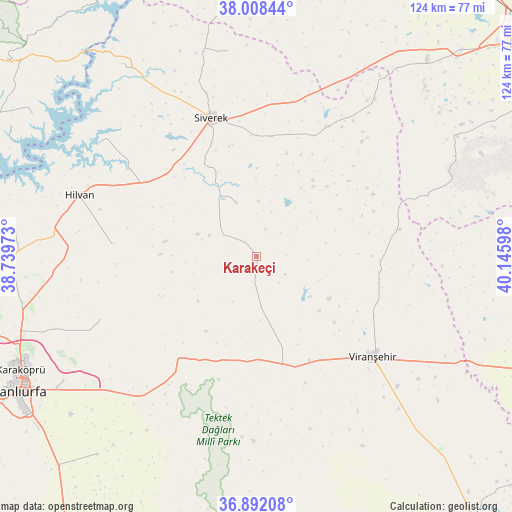
Karakeçi GPS coordinates[2]
37° 27' 8.424" North, 39° 26' 34.26" East
| Map corner | latitude | longitude |
|---|---|---|
| Upper-left | 38.00844°, | 38.73973° |
| Center: | 37.45234°, | 39.44285° |
| Lower-right: | 36.89208°, | 40.14598° |
| Map W x H: | 124.1×124.1 km | = 77.1×77.1mi |
| max Lat: | 42.02683° ⇑76.1% North |
| Karakeçi: | 37.45234° |
| min Lat: | ⇓23.9% South 35.9025° |
| min Long | Karakeçi | max Long |
| 25.90902° | 39.44285° | 44.60099° |
| W 70.8%⇐ | ⇒29.2% E |
Elevation
Elevation of Karakeçi is 785 m = 2575 ft, and this is 67.6 m = 222 ft above average elevation for this country.
| Max E: |
2682 m = 8799 ft | 45.4% |
| Karakeçi | 785 m 2575 ft | |
| Avg. | 717.4 m = 2354 ft | |
Min E: |
0 m = 0 ft | 54.6% |
See also: Turkey elevation on elevation.city.
Geographical zone
Karakeçi is located in North temperate zone (between Tropic of Cancer and the Arctic Circle). Distance of this Northern Tropic circle is 1558.4 km =968.3 mi to South.| Distance of | km | miles | from Karakeçi |
|---|---|---|---|
| North Pole | 5842.8 | 3630.5 | to North |
| Arctic Circle | 3236.9 | 2011.3 | to North |
| Tropic Cancer | 1558.4 | 968.3 | to South |
| Equator | 4164.3 | 2587.6 | to South |


Nearby cities:
15 places around Karakeçi: (largest is in red/bold)
• Demirci
29.1 km =18.1 mi,  98°
98°
• Hilvan
45.5 km =28.3 mi,  289°
289°
• Kabahaydar
32.3 km =20.1 mi,  259°
259°
• Kabahaydar
41.3 km =25.7 mi,  248°
248°
• Karacadağ
35.1 km =21.8 mi,  28°
28°
• Karahan
50.5 km =31.4 mi,  349°
349°
• Ovabağ
55.8 km =34.7 mi,  59°
59°
• Siverek
35.4 km =22 mi,  341°
341°
• Tilfetis
35.1 km =21.8 mi,  275°
275°
• Viranşehir
37.5 km =23.3 mi,  132°
132°
• Yağmurlu
51.4 km =31.9 mi,  190°
190°
• Çamlıdere
46.9 km =29.1 mi,  225°
225°
• Çaylarbaşı
47.1 km =29.3 mi,  305°
305°
• Örenlı
54.9 km =34.1 mi,  195°
195°
• Şekerli
14 km =8.7 mi, 339°
Sources, notices
• [Note1] Compared only with cities in Turkey existing in our database
• [Src1] Map data: © OpenStreetMap contributors (CC-BY-SA)
• [Src2] Other city data from geonames.org with taken over terms of usage.
• [Src3] Geographical zone / Annual Mean Temperature by Robert A. Rohde @ Wikipedia
